Product successfully added to your shopping cart
There are 0 items in your cart. There is 1 item in your cart.
Total products
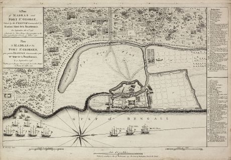
A Plan of Madras and Fort St. George, Taken by the French, Commanded by Monsieur Martre...
John Rocque (*1704 - †1762)Antique map of Madras. Printed in London in the year 1751.
Reference 10977
Description
A very rare plan of Madras during the Carnatic Wars
This copper engraved plan of Madra in India was published by John Rocque in 1751 and engraved by one of his employees Robert Benning.
It shows Madras during the Carnatic Wars. The war marked the beginning of the power struggle between Britain and France in India and of European military ascendancy and political intervention in the subcontinent. Major hostilities began with the arrival of a naval squadron under Mahé de la Bourdonnais, carrying troops from France. On 21st September 1746 Bourdonnais landed his troops near Madras and laid siege to the port, which is documented on this plan. The ships of Bourdonnais are labelled with 'The Bourbon - The Achilles - The Phenix'. The title is printed in English and French as well the 35 number key on the right is bilingual.
We only could locate two copies of the Rocque Madras plan. One in the University Library of Bern, another one in Yale.
For a detailed biography of John Rocque and a list of his works, see Map Forum Issue 3 online at http://www.mapforum.com/05/may.htm
Details
| Cartographer | John Rocque |
| Title | A Plan of Madras and Fort St. George, Taken by the French, Commanded by Monsieur Martre de la Bourdonnais. / Plan de Madras et du Fort St. Georges, pris parles Francois, Commandes par Mr. Matre de la Bourdonnais. |
| Publisher, Year | London, 1751 |
| Plate Size | 34.5 x 51.2 cm (13.6 x 20.2 inches) |
| Sheet Size | 38.2 x 53.0 cm (15.0 x 20.9 inches) |
| Reference | Map Forum Issue 5, The Works of John Rocque #61 |
Condition
Strong and clear impression, small binding holes in top margin, cut on left and right plate mark with 1cm margin to the engraved frame, minor soiling in margin. Very good condition. It is quite unusual to find a separate published map in such preservation.
Cartographer
John Rocque was an English engraver, active in London from 1734. He is best known for a 24-sheet plan of London published in 1746.
Images to Download
If you like to download the image of this map with a resolution of 1200 pixels, please follow the link below.
You can use this image for publication on your personal or commercial websites for free if you set a link to this website. If you need photographs with a higher resolution, please contact us.
John Rocque: A Plan of Madras and Fort St. George, Taken by the French, Commanded by Monsieur Martre de la Bourdonnais. / Plan de Madras....
Antique map of Madras. Printed in London in the year 1751.
India - Rocque, John - A Plan of Madras and Fort St. George,...

