Produkt wurde in den Korb gelegt
Sie haben 0 Artikel in Ihrem Warenkorb. Es gibt 1 Artikel in Ihrem Warenkorb.
Gesamt Artikel
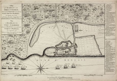
A Plan of Madras and Fort St. George, Taken by the French, Commanded by Monsieur Martre...
John Rocque (*1704 - †1762)Antike Landkarte von Madras. Gedruckt in London im Jahre 1751.
Artikel-Nr. 10977
Beschreibung
Äußerst seltene Ansicht von Madras
This copper engraved plan of Madra in India was published by John Rocque in 1751 and engraved by one of his employees Robert Benning.
It shows Madras during the Carnatic Wars. The war marked the beginning of the power struggle between Britain and France in India and of European military ascendancy and political intervention in the subcontinent. Major hostilities began with the arrival of a naval squadron under Mahé de la Bourdonnais, carrying troops from France. On 21st September 1746 Bourdonnais landed his troops near Madras and laid siege to the port, which is documented on this plan. The ships of Bourdonnais are labelled with 'The Bourbon - The Achilles - The Phenix'. The title is printed in English and French as well the 35 number key on the right is bilingual.
We only could locate two copies of the Rocque Madras plan. One in the University Library of Bern, another one in Yale.
Details
| Kartograph | John Rocque |
| Titel | A Plan of Madras and Fort St. George, Taken by the French, Commanded by Monsieur Martre de la Bourdonnais. / Plan de Madras et du Fort St. Georges, pris parles Francois, Commandes par Mr. Matre de la Bourdonnais. |
| Verlag, Jahr | London, 1751 |
| Bildgröße | 34.5 x 51.2 cm |
| Blattgröße | 38.2 x 53.0 cm |
| Referenz | Map Forum Issue 5, The Works of John Rocque #61 |
Erhaltung
Kräftiger und klarer Abdruck, lleine Bindungslöchlein im oberen Rand, links und rechts entlang des Plattenrandes beschnitten mit 1cm Rand bis zur gestochenen Linie. Sehr guter Zustand.
Kartograph
John Rocque war englischer Kupferstecher, tätig in London ab 1734. Sein bekanntestes Werk ist ein London Plan auf 24 Blättern aus dem Jahre 1746.
Bilder zum Herunterladen
Falls Sie die Bilder dieser Karte in einer Auflösung von 1200 Pixeln herunterladen möchten, folgen Sie bitte unten stehendem Verweis.
Sie können die Bilder auf Ihrer privaten oder kommerziellen Internetseite frei veröffentlichen, sofern Sie einen Verweis (Link) auf diese Webseite setzen. Falls Sie Fotos in höherer Auflösung benötigen, kontaktieren Sie uns bitte.
John Rocque: A Plan of Madras and Fort St. George, Taken by the French, Commanded by Monsieur Martre de la Bourdonnais. / Plan de Madras....
Antike Landkarte von Madras. Gedruckt in London im Jahre 1751.
Indien - Rocque, John - A Plan of Madras and Fort St. George,...

