Product successfully added to your shopping cart
There are 0 items in your cart. There is 1 item in your cart.
Recentissima Novi Orbis sive Americae Septentrionalis et Meridionalis Tabula...
Justus Danckerts (*1635 - †1701)Reference 12861
Description
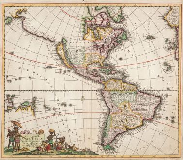
Beautiful old coloured antique map of America by Justus Danckerts. With California still shown as an island. The The highly decorative title cartouche, crowned by two snakes, is surrounded by several gold seekers and a few gold bars.
While the map's overall design and geography closely resemble Frederick de Wit's map from approximately 1675, there are notable differences. Danckerts introduced new place names in the Great Lakes region, and omitted the cartouche in the top left corner. This adjustment allows for a more extensive representation of Dutch-explored lands like Terra Esonis, Yedso, and Iaponle. In contrast to the rare first state, which lacks nomenclature in Terra Esonis, Danckerts addressed this in a second state. The map showcases all five Great Lakes, a pioneering move by de Wit. Interestingly, the two western Lakes, Michigan and Superior, are left open to the west. The Dutch claim to New Netherlands is still visually depicted on this map.
Crafted by the esteemed Danckerts family of Amsterdam, recognized as one of the most distinguished cartographic families in the 17th century, this map reflects the artistry of some of the world's finest draughtsmen and engravers. The Danckerts family is renowned for producing some of the finest atlases of the period, contributing significantly to the cartographic landscape. This particular copy stands out as a fine example, enhanced by meticulous watercoloring executed at the time of its creation.
Details
| Cartographer | Justus Danckerts |
| Title | Recentissima Novi Orbis sive Americae Septentrionalis et Meridionalis Tabula... |
| Publisher, Year | Amsterdam, circa 1685 |
| Plate Size | 49.5 x 57.5 cm (19.5 x 22.6 inches) |
| Sheet Size | 52.0 x 59.5 cm (20.5 x 23.4 inches) |
| Reference | Burden, P.D.: The Mapping of North America No. 725; Tooley, R.V.: The Mapping of America, No. 53. |
Condition
Cartographer
Images to Download
If you like to download the image of this map with a resolution of 1200 pixels, please follow the link below.
You can use this image for publication on your personal or commercial websites for free if you set a link to this website. If you need photographs with a higher resolution, please contact us.
America Continent - Danckerts, Justus - Recentissima Novi Orbis sive Americae...

