Product successfully added to your shopping cart
There are 0 items in your cart. There is 1 item in your cart.
Total products
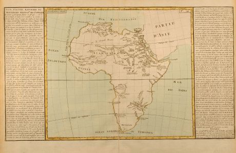
Lacs Fleuve Rivieres et Principales Montagnes de l'Afrique
Jean Baptiste Louis Clouet (*1729 - †1790)Coloured map of Africa. Printed in the year 1787.
Reference 10140
Description
Interesting map of the African continent, describing the lakes, rivers and mountains. From Géographie Moderne by Jean Baptiste Louis Clouet.
Details
| Cartographer | Jean Baptiste Louis Clouet |
| Title | Lacs Fleuve Rivieres et Principales Montagnes de l'Afrique |
| Publisher, Year | 1787 |
| Plate Size | 31.9 x 54.8 cm (12.6 x 21.6 inches) |
Condition
Tear in lower centrefold repaired. Overall fine condition.
Cartographer
Jean Baptiste Louis Clouet was a French cartographer and geographer born 1729 in Rennes. His main work was the Géographie Moderne first issued 1767. He died in 1790.
Images to Download
If you like to download the image of this map with a resolution of 1200 pixels, please follow the link below.
You can use this image for publication on your personal or commercial websites for free if you set a link to this website. If you need photographs with a higher resolution, please contact us.
Jean Baptiste Louis Clouet: Lacs Fleuve Rivieres et Principales Montagnes de l'Afrique.
Coloured map of Africa. Printed in the year 1787.
Africa - Clouet, Jean Baptiste Louis - Lacs Fleuve Rivieres et Principales...

![[Tab. Mo. Primae Partis Aphricae et Tabula Secunde partis Aphricae.] [Tab. Mo. Primae Partis Aphricae et Tabula Secunde partis Aphricae.]](https://www.vintage-maps.com/3651-home_default/fries-north-africa-1525.jpg)
![[Nile River delta] [Nile River delta]](https://www.vintage-maps.com/2049-home_default/muenster-egypt-nile-river-1574.jpg)
