Product successfully added to your shopping cart
There are 0 items in your cart. There is 1 item in your cart.
Total products
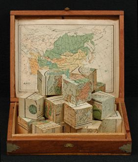
Mappemonde en deux Hemispheres
Charles VerneauCartographical toy consisting of 20 wooden cubes. Fabricated in Paris during the year 1880.
Reference 11309
Description
Appealing cartographical toy, consisting of 20 wooden cubes, each side of each cube with a map section pasted on, thus forming 6 puzzle maps of the world, Europe, Asia, Africa, the Americas and France. Laid in a contemporary wooden box, with 5 uncut coloured lith. maps of the continents and France enclosed as a key, and world map pasted on the lid.
Details
| Cartographer | Charles Verneau |
| Title | Mappemonde en deux Hemispheres |
| Publisher, Year | Paris, circa 1880 |
Condition
Uncut maps lightly browned, tear to France laid down, world map somewhat stained, slight foxing mounted map sections.
Cartographer
Charles Verneau was active in Paris during the second half of the 19th Century.
Images to Download
If you like to download the image of this map with a resolution of 1200 pixels, please follow the link below.
You can use this image for publication on your personal or commercial websites for free if you set a link to this website. If you need photographs with a higher resolution, please contact us.
Charles Verneau: Mappemonde en deux Hemispheres.
Cartographical toy consisting of 20 wooden cubes. Fabricated in Paris during the year 1880.


![Ch'onha Chido [Atlas of all under Heaven] Ch'onha Chido [Atlas of all under Heaven]](https://www.vintage-maps.com/3336-home_default/anonymous-korean-manuscript-atlas-chonha-chido-1820.jpg)
![Ch'onha Chido [Atlas of all under Heaven] Ch'onha Chido [Atlas of all under Heaven]](https://www.vintage-maps.com/4291-home_default/anonymous-korean-manuscript-atlas-chonha-chido-1800.jpg)
![Ch'onha chido [Atlas of all under Heaven] Ch'onha chido [Atlas of all under Heaven]](https://www.vintage-maps.com/3314-home_default/anonymous-korean-woodblock-atlas-chonha-chido-1750.jpg)