Product successfully added to your shopping cart
There are 0 items in your cart. There is 1 item in your cart.
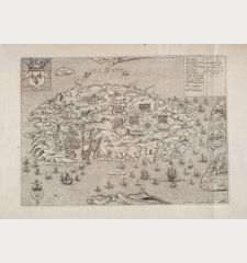
Assedio de l'Isola di Malta 1565 / Valetta, nova Citta di Malta
Domenico ZenoiReference 11434
Description
Albert Ganado, Proceedings of History Week 1983. Malta: The [Malta] Historical Society, 1984, pp. 150:
... The prototype of the third group is Antonio Lafreri's map of 1551 published in Rome: MELITA Insula, quam hodie MALTAM uocant. It was copied faithfully and published in Venice by Donato Bertelli, in the 1550s: Il uero disegno dell Isola di Malta, as well as by Nicolò Nelli in 1565: IL VERO RITRATTO DE L'ISOLA D'MALTA — MELITA Insula, quam hodie MALTA uocant. A number of maps portraying the siege, apart from Lafreri's own siege maps, adopted the same shape: L'Vltimo disegno de l'isola di Malta by Domenico Zenoi; ASSEDIO DE L'ISOLA DI MALTA .1565. by Zenoi, published by Paolo Forlani in 1567 in his book on cities and fortresses; the maps published respectively in Cirni's (1567), Viperano's (1567) and Balbi da Corregio's (1568) accounts of the siege. Ortelius (1570) and Porcacchi (1572) followed more or less the same pattern.
Details
| Cartographer | Domenico Zenoi |
| Title | Assedio de l'Isola di Malta 1565 / Valetta, nova Citta di Malta |
| Publisher, Year | Venice, 1567-69 |
| Plate Size | 15.2 x 20.5 cm (6.0 x 8.1 inches) |
| Sheet Size | 27.5 x 41.2 cm (10.8 x 16.2 inches) |
| Reference | Woodward, D.: Catalogue of Watermarks in the Italian Printed Maps ca 1540-1600, No. 91; Ganado, A.: Proceedings of History Week 1983. Malta: The [Malta] Historical Society, 1984, pp. 150 |
Condition
Cartographer
Images to Download
If you like to download the image of this map with a resolution of 1200 pixels, please follow the link below.
You can use this image for publication on your personal or commercial websites for free if you set a link to this website. If you need photographs with a higher resolution, please contact us.
Malta - Zenoi, Domenico - Assedio de l'Isola di Malta 1565 /...


