Product successfully added to your shopping cart
There are 0 items in your cart. There is 1 item in your cart.
Total products
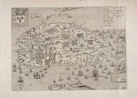
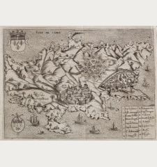
Isle et Siege de Malte
Henry RaigniauldAntique map of Malta. Printed in Paris by J. Baudoin - A. de Naberat in 1629 or 1640.
Reference 12552
Description
Rare antique map of Malta engraved by H. Raigniauld. From Histoire des Chevaliers de l'Ordre de S. Iean de Hierusalem by J. Baudoin or from the edition by A. de Naberat. The maps shows the Great Siege of Malta in 1565. With two coats-of-arms, many ships around the island, a key from 1 to 14. The places mostly depicted as small town views, numerous fortified towers, below parts of Sicily, to the right Gozo, Comino and Filfla. Oriented to the south.
Details
| Cartographer | Henry Raigniauld |
| Title | Isle et Siege de Malte |
| Publisher, Year | J. Baudoin - A. de Naberat, Paris, 1629 or 1640 |
| Plate Size | 20.0 x 27.3 cm (7.9 x 10.7 inches) |
| Sheet Size | 27.7 x 41.6 cm (10.9 x 16.4 inches) |
| Reference | Mason, R. & Willis, P.: Maps of Malta in the Museum and Library of the Order of St. John: A Short Catalogue, No. 28; Ganado, A. & Agius, M.: A Study in dept of 143 Maps representing The Great Siege of Malta Of 1565, No. 28 |
Condition
Some browning in upper margin. 3 old vertical folds. Very good condition with wide margins.
Cartographer
Henry Raigniauld, also known as Raignauld, was a French engraver during the early 1600s.
Images to Download
If you like to download the image of this map with a resolution of 1200 pixels, please follow the link below.
You can use this image for publication on your personal or commercial websites for free if you set a link to this website. If you need photographs with a higher resolution, please contact us.
Henry Raigniauld: Isle et Siege de Malte.
Antique map of Malta. Printed in Paris by J. Baudoin - A. de Naberat in 1629 or 1640.

