Product successfully added to your shopping cart
There are 0 items in your cart. There is 1 item in your cart.
Total products
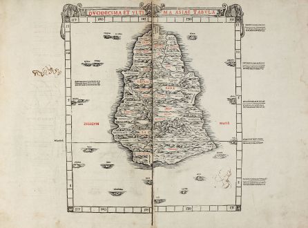
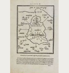
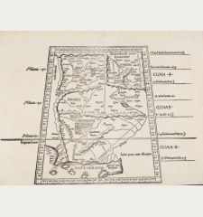
Duodecima et ultima Asiae tabula
Bernardus SylvanusAntique woodcut map of Taprobana, Sri Lanka, Ceylon. Printed in Venice by J. Pentius de Leucho in 1511.
Reference 11065
Description
Early woodcut map of Ceylon / Sri Lanka printed in red and black. From Bernardus Sylvanus also known as Bernardo Silvano of Eboli Ptolemy edition 'Claudii Ptholemaei Alexandrini liber Geographicae...', printed 1511 in Venice. Sylvanus created a unique hybrid of Classical and modern information on his maps for his 1511 edition. He fitted Ptolemy's list of provinces, towns, as they existed in the Classical period to the modern geographical outline of the coasts, rivers, and mountains. The map have been printed in two colours - black and red, one of the earliest examples of two colour printing.
Each of the map sheets of Sylvanus printed on both sides, so halves of two different maps are on the back side of this map. As a result, Sylvanus maps are very rare on the market and certain maps virtually never appear on the market, where they appeared on the verso of maps which were more heavily soughtafter by collectors. In this case, verso right half shows the map of India beyond the Ganges with the description of the Chinese Sea with Southeast Asia, titled 'Undecima Asiae Tabula'.
Each of the map sheets of Sylvanus printed on both sides, so halves of two different maps are on the back side of this map. As a result, Sylvanus maps are very rare on the market and certain maps virtually never appear on the market, where they appeared on the verso of maps which were more heavily soughtafter by collectors. In this case, verso right half shows the map of India beyond the Ganges with the description of the Chinese Sea with Southeast Asia, titled 'Undecima Asiae Tabula'.
Details
| Cartographer | Bernardus Sylvanus |
| Title | Duodecima et ultima Asiae tabula |
| Publisher, Year | J. Pentius de Leucho, Venice, 1511 |
| Plate Size | 37.5 x 37.5 cm (14.8 x 14.8 inches) |
| Sheet Size | 42.0 x 56.5 cm (16.5 x 22.2 inches) |
| Reference | Karrow, R.W. (16 c.) 75/54. |
Condition
Printed on two leaves which have been rejoined, some scribble in ink by an old hand, very good conditions.
Cartographer
Bernardus Sylvanus also known as Bernardo Silvano of Eboli, created a unique hybrid of Classical and modern information on his maps for the 1511 Ptolemy edition Claudii Ptholemaei Alexandrini liber Geographicae..., printed in Venice. He fitted Ptolemy's list of provinces, towns, and other places as they existed in the Classical period to the modern geographical outline of the coasts, rivers, and mountains. The maps have been printed in two colours - black and red, one of the earliest examples of two colour printing.
Images to Download
If you like to download the image of this map with a resolution of 1200 pixels, please follow the link below.
You can use this image for publication on your personal or commercial websites for free if you set a link to this website. If you need photographs with a higher resolution, please contact us.
Bernardus Sylvanus: Duodecima et ultima Asiae tabula.
Antique woodcut map of Taprobana, Sri Lanka, Ceylon. Printed in Venice by J. Pentius de Leucho in 1511.
India - Sylvanus, Bernardus - Duodecima et ultima Asiae tabula

