Product successfully added to your shopping cart
There are 0 items in your cart. There is 1 item in your cart.
Total products
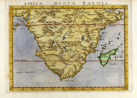
Africa nuova tavola
Girolamo Ruscelli (*1504 - †1566)Coloured map of South Africa. Printed in Venice by V. Valgrisi in 1562.
Reference 10838
Description
Decorative coloured 16th century map of South Africa by G. Ruscelli. From the latin Ptolemy edition of Gastaldi-Ruscelli by V. Valgrisi, printed in Venice 1562.
Details
| Cartographer | Girolamo Ruscelli |
| Title | Africa nuova tavola |
| Publisher, Year | V. Valgrisi, Venice, 1562 |
| Plate Size | 18.6 x 24.8 cm (7.3 x 9.8 inches) |
| Sheet Size | 23.0 x 32.0 cm (9.1 x 12.6 inches) |
| Reference | Tooley, Continent S9. |
Condition
Small margin on top, two small worm holes in lower white margin, fine condition.
Cartographer
Girolamo Ruscelli, an Italian Alchemist, physician and cartographer, was born around 1504 in Viterbo. He has revised the Ptolemy Geography, which was issued from 1561 until 1599 in Venice. The new copper engraved maps are based on G. Gastaldi's edition of 1548. He died 1566 in Venice.
Images to Download
If you like to download the image of this map with a resolution of 1200 pixels, please follow the link below.
You can use this image for publication on your personal or commercial websites for free if you set a link to this website. If you need photographs with a higher resolution, please contact us.
Girolamo Ruscelli: Africa nuova tavola.
Coloured map of South Africa. Printed in Venice by V. Valgrisi in 1562.

![[Tab. Mo. Primae Partis Aphricae et Tabula Secunde partis Aphricae.] [Tab. Mo. Primae Partis Aphricae et Tabula Secunde partis Aphricae.]](https://www.vintage-maps.com/3651-home_default/fries-north-africa-1525.jpg)
![[Nile River delta] [Nile River delta]](https://www.vintage-maps.com/2049-home_default/muenster-egypt-nile-river-1574.jpg)
