Product successfully added to your shopping cart
There are 0 items in your cart. There is 1 item in your cart.
Total products

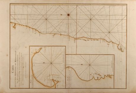
Carte de la Côte orientale de Madagascar depuis Mananzari jusques et compris l'anse du...
Jean Baptiste Mannevillette (*1707 - †1780)Old coloured sea chart of South Madagascar, Indian Ocean, Sea Chart. Printed in Paris in the year 1775.
Reference 10118
Description
Large original coloured sea chart of Madagascar. Showing the southeast coastline of Madagascar and two inset maps of the harbours and anchorage of Tolanaro and the islands of Saite Luce titled Plan de l'Anse du Fort Dauphin and Plan de la Baye et des Islots de Ste. Luce. From the second revised and enlarged edition of Le Neptune Oriental published 1775 in Paris.
Details
| Cartographer | Jean Baptiste Mannevillette |
| Title | Carte de la Côte orientale de Madagascar depuis Mananzari jusques et compris l'anse du Fort Dauphin |
| Publisher, Year | Paris, 1775 |
| Plate Size | 66.6 x 48.4 cm (26.2 x 19.1 inches) |
Condition
Some waterstains in margin, otherwise excellent condition.
Cartographer
During many subsequent voyages he [Jean Baptiste Nicolas Denis d'Après de Mannevillette] assembled a collection of material for a projected hydrographic atlas which, with the support of Académie des Sciences, was published in Paris in 1745 under the title Le Neptune Oriental. In spite of the popularity of the first issue, it failed to satisfy the author and he spent nearly thirty years, often with the assistance of his friend, Alexander Dalrymple, the English hydrographer, in the preparation of the revised and enlarged edition which eventually was issued in 1775. (Antique Maps, Moreland & Bannister)
Images to Download
If you like to download the image of this map with a resolution of 1200 pixels, please follow the link below.
You can use this image for publication on your personal or commercial websites for free if you set a link to this website. If you need photographs with a higher resolution, please contact us.
Jean Baptiste Mannevillette: Carte de la Côte orientale de Madagascar depuis Mananzari jusques et compris l'anse du Fort Dauphin.
Old coloured sea chart of South Madagascar, Indian Ocean, Sea Chart. Printed in Paris in the year 1775.
East Africa - Mannevillette, Jean Baptiste - Carte de la Côte orientale de Madagascar...


![[Maidegascar, Zanzibar, Scorsia, Inebila, Imangla, Scilam, Dondina] [Maidegascar, Zanzibar, Scorsia, Inebila, Imangla, Scilam, Dondina]](https://www.vintage-maps.com/2957-home_default/bordone-east-africa-madagascar-sri-lanka-1528-1565.jpg)


