Product successfully added to your shopping cart
There are 0 items in your cart. There is 1 item in your cart.
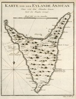
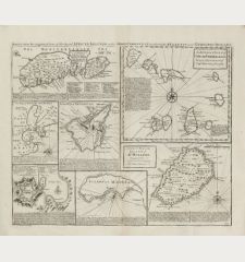
Karte von den Eylande Anjouan Eines von den Eylanden Comore
Jacques Nicolas Bellin (*1703 - †1772)Reference 10574
Description
Details
| Cartographer | Jacques Nicolas Bellin |
| Title | Karte von den Eylande Anjouan Eines von den Eylanden Comore |
| Publisher, Year | Arkstee & Merkus, Leipzig, 1749 |
| Plate Size | 21.1 x 16.4 cm (8.3 x 6.5 inches) |
| Sheet Size | 24.8 x 18.5 cm (9.8 x 7.3 inches) |
Condition
Cartographer
Jacques Nicolas Bellin was born 1703 in Paris. He worked over fifty years for the Dépot des Cartes et Plans de la Marine. He was appointed Ingénieur hydrographe de la Marine in 1741. Later he became Hydrographe du Roi and a member of the Royal Society in London. He died 1772 in Versailles.
Main publications:
- Maps for Prévost's L'Histoire Générale des Voyages, 1747-61.
- Atlas Maritime. 1751. - Neptune Francois. 1753.
- Hydrographie Francoise. 1756.
- Petit Atlas Maritime. 1764.
Images to Download
If you like to download the image of this map with a resolution of 1200 pixels, please follow the link below.
You can use this image for publication on your personal or commercial websites for free if you set a link to this website. If you need photographs with a higher resolution, please contact us.
Africa - Bellin, Jacques Nicolas - Karte von den Eylande Anjouan Eines von...

![[Tab. Mo. Primae Partis Aphricae et Tabula Secunde partis Aphricae.] [Tab. Mo. Primae Partis Aphricae et Tabula Secunde partis Aphricae.]](https://www.vintage-maps.com/3651-home_default/fries-north-africa-1525.jpg)
![[Nile River delta] [Nile River delta]](https://www.vintage-maps.com/2049-home_default/muenster-egypt-nile-river-1574.jpg)
