Product successfully added to your shopping cart
There are 0 items in your cart. There is 1 item in your cart.
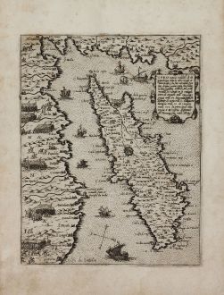
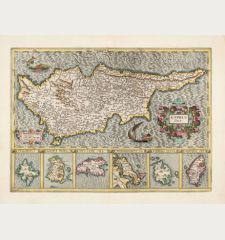
Cipro insula nobiliss.a ch di grandezza tutte le altre ...
Giovanni Francesco Camocio (*1501 - †1575)Reference 11177
Description
Stylianou notes to this plate:
'Cipro insula ..., with the coasts of Caramania and Soria, is depicted with east at the top. There is no separate title to the map. In the top right, we have the historical descriptive note: Cipro insula nobiliss.a di grandezza tutte le altre eccede, et detta Beata p(er) la sua mirabile fertilita di uino, grano, oglio, lino, babagio, lane legnami, uitrioli, sale, pece, metalli, et e diuisa in 11 contadi, tient di circuito mill. 550. longezza mill. 110. largezza mill. 65. distante di Soria mill. 60. dalla caramaniia (sic) mill. 50. di Candia mill. 500. la principal citta regia e Nicossia distante di Famagosta mill. 38.
The map of the island appears to be a recension of that by Paolo Forlani already described. There are some eliminations of place-names around the coast and some additions in the interior, which is divided into the same 11 districts. Nicosia retains its diagrammatic plan as a cartographical symbol.
There is no imprint or any indication in the descriptive note about the date of issue of the map. On the coast of Caramania, however, there are depicted several formations of Turkish troops - foot-soldiers and cavalry - apparently in preparation for the attack on the island in July 1570. In this context, a date before July 1570, can be suggested for the map.'
Isole Famose porti, fortezze, e terre maritime is one of the most important of these atlases, issued first by Camocio in 1566. It comprises a collection of maps of the areas under the influence of the Venetians. Shown is the situation during the siege of Vienna in 1566, and the battle between the Venetians and Turks in the Mediterranean during the years 1570-1573. Mainly included are maps of the Mediterranean coasts, the main islands, and city views. The atlas was published between 1566 and 1574 by Camocio without a title, after 1575 it was issued by Donato Bertelli with a printed title, also printed from the original plates.
Details
| Cartographer | Giovanni Francesco Camocio |
| Title | Cipro insula nobiliss.a ch di grandezza tutte le altre ... |
| Publisher, Year | G. F. Camocio, Venice, before July 1570 |
| Plate Size | 20.2 x 15.9 cm (8.0 x 6.3 inches) |
| Sheet Size | 27.5 x 20.3 cm (10.8 x 8.0 inches) |
| Reference | Stylianou, A. & J.: The History of the Cartography of Cyprus, No. 42 (fig. 47); Zacharakis, C. G.: A Catalogue of printed Maps of Greece, 3rd edition, #796/522 |
Condition
Cartographer
Giovanni Francesco Camocio was active as map publisher in Venice between 1558 and 1575. He was one of the most important mapmakers of the Lafreri-school.
During the short period between the publication of Sebastian Münster's Geographia (1540) in Basel and Abraham Ortelius Theatrum Orbis Terrarum (1570) in Antwerp, Italy was the most important place of map production in Europe. The output in Rome and Venice was no less than 660 different maps of the world, which were based mostly on large woodcut maps. These Italian copper engraved maps were used, among others, by Mercator and Ortelius as templates. The individual maps of different formats were mostly compiled at the request of the buyer and bound by expanding the margin of the smaller maps. For the resulting bound collection of maps, the name Lafreri-Atlas has established. Besides the eponym Antonio Lafreri and Camocio, we have to mention Bertelli, Duchetti and Forlani, which also published bound collections of maps. As the most important representative of this period, the Venetian cartographer Giacomo Gastaldi overshadowed his combatant in volume and importance.
Besides Camocio's single-sheet maps of the continents and the world, he published an Isolario, a collection of island maps and plans of harbour. It was published between c. 1566 and 1574 without a title, after 1575 with the title Isole Famose Porti, Fortezze E Terre Maritime by Donato Bertelli who published the plates under his name after the death of Camocio.
Images to Download
If you like to download the image of this map with a resolution of 1200 pixels, please follow the link below.
You can use this image for publication on your personal or commercial websites for free if you set a link to this website. If you need photographs with a higher resolution, please contact us.
Cyprus - Camocio, Giovanni Francesco - Cipro insula nobiliss.a ch di grandezza...



![[Die Tafel gibt ein klein anzeigung...] [Die Tafel gibt ein klein anzeigung...]](https://www.vintage-maps.com/1544-home_default/muenster-holy-land-israel-cyprus-1574.jpg)

![[Asia Minor] [Asia Minor]](https://www.vintage-maps.com/3717-home_default/muenster-turkey-asia-minor-1550.jpg)
