Product successfully added to your shopping cart
There are 0 items in your cart. There is 1 item in your cart.
Africa
![Holle, North Africa, Libya, Tunisia, Sardinia and Sicily: [Secunda Affrice tabula continet Affricam & insulae que circa ipsam sunt Parallel]]( "Lienhart Holle: [Secunda Affrice tabula continet Affricam & insulae que circa ipsam sunt Parallel]")
[Secunda Affrice tabula continet Affricam & insulae que circa ipsam sunt Parallel]
Lienhart Holle, Ulm, July 1482
One of the earliest obtainable printed maps of North Africa. From the first Ulm edition of 1482.Untitled woodcut map, showing present-day Libya, Tunisia, Sardinia and Sicily based upon...
[Secunda Affrice tabula continet Affricam & insulae que circa ipsam sunt...
1482 - Lienhart Holle
11524First Edition of an Important 15th Century Map of North Africa with Sardinia and Sicily. Printed in July 1482 in Ulm by Lienhard Holle.
Sold
Memphis
Anton Koberger, Nuremberg, 1493
Incunabulum leaf in folio showing a cityview of Cairo / Egypt and Abraham by H. Schedel from the famous "Nuremberg Chronicle" in German edition printed 1493. Verso a biblical scene showing an angel...
Memphis
1493 - Hartmann Schedel
10784Antique woodcut town view of Cairo. Printed in Nuremberg by Anton Koberger in 1493.
Sold
Tertia Africae Tabula
Johannes Schott, Strasbourg, 1513 or 1520
Early woodcut map of North Africa from M. Waldseemuller of 1513 (1520). Showing the region from Bengazi in Libya up to Egypt with the Red Sea.This ptolemaic map comes from the first so called...
Tertia Africae Tabula
1513 - Martin Waldseemüller
11144Antique woodcut map of the Red Sea, Egypt, Libya, North Africa. Printed in Strasbourg by Johannes Schott in 1513 or 1520.
Sold
Africa Lybia Morenlandt mit Allen Künigreichen so zu unsern zeiten darin gefunden werden.
Heinrich Petri, Basle, 1540 (1574)
The earliest obtainable printed map to show all of Africa. First published in 1540 by Sebastian Munster, this map is also famous because of its rich mythical content. The Monoculi or cyclops...
Africa Lybia Morenlandt mit Allen Künigreichen so zu unsern zeiten darin...
1540 - Sebastian Münster
11325Coloured woodcut map of Africa. Printed in Basle by Heinrich Petri in 1574.
Sold
Africa Libya Morland mit allen künigreichen so zu unsern zeiten darin gefunden werden.
Heinrich Petri, Basle, 1540 (1550)
The earliest obtainable printed map to show all of Africa. First published in 1540 by Sebastian Munster, this map is also famous because of its rich mythical content. The Monoculi or cyclops...
Africa Libya Morland mit allen künigreichen so zu unsern zeiten darin...
1540 - Sebastian Münster
12608Coloured woodcut map of the African continent. Printed in Basle by Heinrich Petri in 1550.
Sold
Aphricae tabula secunda continet
Trechsel, Vienne, 1541
Untitled trapezoidal Ptolemaic woodcut map of North Africa. From the 1541 Vienne (Dauphiné) edition of Ptolemy's Geographia published by Gaspar Trechsel and sold by Hughes de la Porte in Lyon. The...
Aphricae tabula secunda continet
1541 - Laurent Fries
10111Coloured woodcut map of Sardinia, Malta, North Africa. Printed in Vienne by Trechsel in 1541.
Sold![Münster, Egypt, Nile River, 1550: [Nile River delta] / Bacchus]( "Sebastian Münster: [Nile River delta] / Bacchus")
[Nile River delta] / Bacchus
Heinrich Petri, Basle, 1550
Early woodcut map of the Nile River delta by Sebastian Münster. Shows the Mediterranean coast with parts of the Gulf of Suez. With Alexandria in the West, Cairo with the Pyramids of Giza in the...
[Nile River delta] / Bacchus
1550 - Sebastian Münster
12597Antique woodcut map of the Nile River. Printed in Basle by Heinrich Petri in 1550.
Sold
Africa nuova tavola
V. Valgrisi, Venice, 1562
Decorative coloured 16th century map of South Africa by G. Ruscelli. From the latin Ptolemy edition of Gastaldi-Ruscelli by V. Valgrisi, printed in Venice 1562.
Africa nuova tavola
1562 - Girolamo Ruscelli
10838Coloured map of South Africa. Printed in Venice by V. Valgrisi in 1562.
Sold
Affrica mit seinen Besondern Laendern, Thieren, und wunderbarlichen dingen.
Heinrich Petri, Basle, 1574
Early woodcut map of Africa by Sebastian Münster. On the full text sheet. From the German edition of Sebastian Münster's Cosmography, titled Cosmographey oder beschreibung aller Länder , published...
Affrica mit seinen Besondern Laendern, Thieren, und wunderbarlichen dingen.
1574 - Sebastian Münster
11404Coloured woodcut map of Africa. Printed in Basle by Heinrich Petri in 1574.
Sold
Warhaffte abcontrafehtung der Mechtigen und Vesten Statt Alkair
Heinrich Petri, Basle, 1574
Early woodcut view of Cairo in Egypt by Sebastian Münster. Showing the city from a birdeye perspective with the Pyramids of Giza, the Great Sphinx of Giza, crocodiles and ships in the Nile River....
Warhaffte abcontrafehtung der Mechtigen und Vesten Statt Alkair
1574 - Sebastian Münster
11683Antique woodcut town view of Cairo. Printed in Basle by Heinrich Petri in 1574.
Sold![Münster, North Africa, Tunisia, Tunis, 1574: [Tunis]]( "Sebastian Münster: [Tunis]")
[Tunis]
Heinrich Petri, Basle, 1574
Beautiful coloured view of Tunis in Tunisia by Sebastian Münster. Shows the zoological and botanical garden, castle Goleta, a Harem and a Thermae. From the German edition of Sebastian Münster's...
[Tunis]
1574 - Sebastian Münster
11692Coloured woodcut map of Tunis, Tunisia. Printed in Basle by Heinrich Petri in 1574.
Sold
Tunes Urbs
Cologne, 1575
Attractive cityview of Tunis in Tunisia / Africa. Showing the Imperial attack on Tunis in 1573. Latin text on verso.
Tunes Urbs
1575 - Braun & Hogenberg
10017Antique town view of Tunis. Printed in Cologne in the year 1575.
Sold
Warhaffte abcontrafehtung der machtigen und vesten Statt Alkair
Petri, Basle, circa 1575
Woodcut view of Cairo in Egypt by Sebastian Münster. From a German edition of the "Cosmographey". Showing the city from birdeye perspective with the Pyramids, the Great Sphinx of Giza, crocodiles...
Warhaffte abcontrafehtung der machtigen und vesten Statt Alkair
1575 - Sebastian Münster
10393Coloured woodcut town view of Cairo, Egypt. Printed in Basle by Petri circa 1575.
Sold
Mombaza
Nicolas Chesneau, Michel Sonnius, Paris, 1575
A scarce and early woodcut view of Mombasa, Kenya. Ruled in brown ink. As a woodcut view, it is extremely fine cut. On the full text sheet. The view comes from the French edition of the...
Mombaza
1575 - Francois de Belleforest
11416Antique woodcut town view of Mombasa, Kenya. Printed in Paris by Nicolas Chesneau, Michel Sonnius in 1575.
Sold
Cairus, Quae Olim Babylon Aegypt Maxima Urbs / Le Grand Caire
Nicolas Chesneau, Michel Sonnius, Paris, 1575
A large and rare woodcut view of Cairo with the Nile river, the Great Pyramids and Sphinx of Giza. Based on a engraving from Braun and Hogenberg's Civitates orbis terrarum .This woodcut was...
Cairus, Quae Olim Babylon Aegypt Maxima Urbs / Le Grand Caire
1575 - Francois de Belleforest
11678Antique woodcut town view of Cairo. Printed in Paris by Nicolas Chesneau, Michel Sonnius in 1575.
Sold
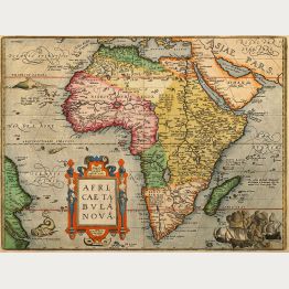
Africae Tabula Nova
Gillis van den Rade, Antwerp, 1575
Antique map of Africa by Abraham Ortelius. From the 1575 Latin edition of Theatrum Orbis Terrarum by Abraham Ortelius. Second state of the plate, still the date 1570 is present in the cartouche...
Africae Tabula Nova
1575 - Abraham Ortelius
12410Coloured map of the African continent. Printed in Antwerp by Gillis van den Rade in 1575.
Sold
Affricae tabula nova / Africa, Lybia, Morenlandt, mit allen Königreichen so jetziger Zeit darumb...
Petri, Basle, circa 1580
Attractive woodcut map showing the African continent. From a German edition of Cosmographia by Sebastian Munster printed from Petri in Basel 1580. "This map ... was based on Ortelius ... The coast...
Affricae tabula nova / Africa, Lybia, Morenlandt, mit allen Königreichen...
1580 - Sebastian Münster
10110Coloured woodcut map of the African continent. Printed in Basle by Petri circa 1580.
Sold
Cairus Quae Olim Babylon Aegypti Maxima Urbs
Cologne, circa 1580
Attractive birdeye view of Cairo in Egypt with the Nile river, the Great Pyramids and Sphinx of Giza. Beautiful original colour. German text on verso. From a German edition of "Civitates orbis...
Cairus Quae Olim Babylon Aegypti Maxima Urbs
1580 - Braun & Hogenberg
10146Old coloured town view of Giza, Cairo, Egypt. Printed in Cologne circa 1580.
Sold
Africa mit seinen besundern Ländern, Thieren, und wunderbarlichen Dingen
Petri, Basle, circa 1580
Attractive original coloured woodcut map showing the African continent. From a German edition of Cosmographia by Sebastian Munster printed from Petri in Basel. Two interesting woodcut on backside:...
Africa mit seinen besundern Ländern, Thieren, und wunderbarlichen Dingen
1580 - Sebastian Münster
10130Coloured woodcut map of Africa. Printed in Basle by Petri circa 1580.
Sold
Algier
Petri, Basle, circa 1580
Woodcut cityview of Algier / Algeria / North Africa. From a German edition of Cosmographia by Sebastian Munster printed from Petri in Basel.
Algier
1580 - Sebastian Münster
10132Antique woodcut town view of Algier. Printed in Basle by Petri circa 1580.
Sold
Tunis
Petri, Basle, circa 1580
Woodcut cityview of Tunis / Tunisia / North Africa including zoological and botanical garden, castle Goleta, a Harem and a Thermae. From a German edition of Cosmographia by Sebastian Munster...
Tunis
1580 - Sebastian Münster
10131Antique woodcut town view of Tunis. Printed in Basle by Petri circa 1580.
Sold
Africa Tertia pars Terrae
Magdeburg, 1581
Rare and early woodcut map of Africa by Heinrich Bunting. The map has an unusual shape, tapering to a narrow angle in the south. Several rivers appear in West Africa and as tributaries to the Nile....
Africa Tertia pars Terrae
1581 - Heinrich Bünting
11197Coloured woodcut map of Africa. Printed in Magdeburg in the year 1581.
Sold
Affricae tabula nova / Africa, Lybia, Morenlandt, mit allen Königreichen so jetziger Zeit darumb
Sebastian Petri, Basle, 1588 (1598)
Beautiful original antique map of Africa by Sebastian Münster. Based on the Ortelius map of 1570, the coast of Brazil was added. With two sailing ships and a sea monster. On verso the title with a...
Affricae tabula nova / Africa, Lybia, Morenlandt, mit allen Königreichen...
1588 - Sebastian Münster
12429Original antique map of Africa. Printed in Basle by Sebastian Petri in 1598.
Sold
Natoliae, quae olim Asia Minor Nova Descriptio - Aegypti Recentior Descriptio - Carthaginis...
Antwerp, 1595
Coloured copper engraved map of Turkey by A. Ortelius. On right side a map of Egypt and one of Tunis. Three map on one sheet printed from one plate. From the 1595 Latin edition of 'Theatrum Orbis...
Natoliae, quae olim Asia Minor Nova Descriptio - Aegypti Recentior...
1595 - Abraham Ortelius
10854Coloured map of Tunis, Egypt, Cyprus, Turkey. Printed in Antwerp in the year 1595.
Sold
![Holle, North Africa, Libya, Tunisia, Sardinia and Sicily: [Secunda Affrice tabula continet Affricam & insulae que circa ipsam sunt Parallel]](https://www.vintage-maps.com/1834-home_default/holle-north-africa-libya-tunisia-sardinia-and-sicily.jpg "Lienhart Holle: [Secunda Affrice tabula continet Affricam & insulae que circa ipsam sunt Parallel]")


![Münster, Egypt, Nile River, 1550: [Nile River delta] / Bacchus](https://www.vintage-maps.com/3705-home_default/muenster-egypt-nile-river-1550.jpg "Sebastian Münster: [Nile River delta] / Bacchus")


![Münster, North Africa, Tunisia, Tunis, 1574: [Tunis]](https://www.vintage-maps.com/2072-home_default/muenster-north-africa-tunisia-tunis-1574.jpg "Sebastian Münster: [Tunis]")


