Produkt wurde in den Korb gelegt
Sie haben 0 Artikel in Ihrem Warenkorb. Es gibt 1 Artikel in Ihrem Warenkorb.
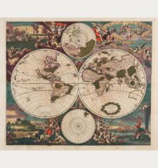
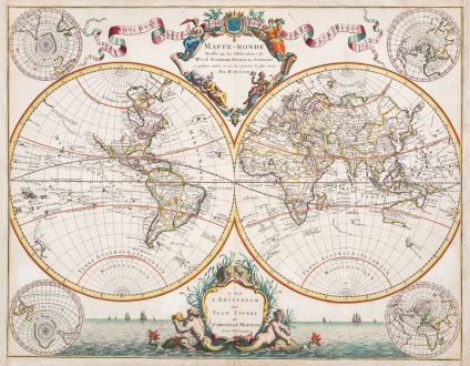
Mappe-Monde Dresse sur les Observations de Mrs de l'Academie Royale des Sciences
Covens and MortierArtikel-Nr. 12553
Beschreibung
Prächtige antike Weltkarte von J. Covens und P. Mortier. Die Karte basiert auf der Weltkarte von Guillaume De L'Isle aus dem Jahr 1700. Gegenüber der Karte von De L'Isle jetzt mit vier zusätzlichen Polkarten und einer großartigen maritimen Szenerie im gesamten unteren Bereich.
R. Shirley beschreibt die De L'Isle Karte in The Mapping of the World unter der Nr. 603 wie folgt:
He [De L'Isle] was one of the first, in his world map, to correct the extended length of the Mediterranean and to give back to California its true peninsular formation. However, unlike Jaillot, he appears to link New Guinea to Australia and also errs in joining Japan to the conjectural land of Yeco or Yedso to its north. The title to his world map is framed within an elegant cartouche at the top, balanced on either side by a flowing banner... On the map are marked the tracks of the principal circumnavigators.
In common with his other maps, De L'Isle's world map was revised several times... Outside of France other cartographers recognised De L'Isle's superior work. His plate was copied by Pieter Schenk for publication in Amsterdam in 1708 and further copies were made by Covens and Mortier and other publishers from the 1720s onwards.
Details
| Kartograph | Covens and Mortier |
| Titel | Mappe-Monde Dresse sur les Observations de Mrs de l'Academie Royale des Sciences |
| Verlag, Jahr | Covens & Mortier, Amsterdam, um 1730 |
| Bildgröße | 50.2 x 64.3 cm |
| Blattgröße | 52.2 x 67.3 cm |
| Referenz | Shirley, R. W.: The Mapping of the World, No. 603 |
Erhaltung
Kartograph
Bilder zum Herunterladen
Falls Sie die Bilder dieser Karte in einer Auflösung von 1200 Pixeln herunterladen möchten, folgen Sie bitte unten stehendem Verweis.
Sie können die Bilder auf Ihrer privaten oder kommerziellen Internetseite frei veröffentlichen, sofern Sie einen Verweis (Link) auf diese Webseite setzen. Falls Sie Fotos in höherer Auflösung benötigen, kontaktieren Sie uns bitte.
Weltkarten - Covens and Mortier - Mappe-Monde Dresse sur les Observations de...

![Ch'onha Chido [Atlas of all under Heaven] Ch'onha Chido [Atlas of all under Heaven]](https://www.vintage-maps.com/3336-home_default/anonymous-japan-korea-koreanischer-manuskript-atlas-chonha-chido.jpg)
![Ch'onha Chido [Atlas of all under Heaven] Ch'onha Chido [Atlas of all under Heaven]](https://www.vintage-maps.com/4291-home_default/anonymous-japan-korea-koreanischer-manuskript-atlas-chonha-chido.jpg)
