Produkt wurde in den Korb gelegt
Sie haben 0 Artikel in Ihrem Warenkorb. Es gibt 1 Artikel in Ihrem Warenkorb.
Gesamt Artikel
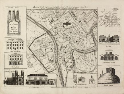
A Plan of the City of York Survey'd By Peter Chassereau / Plan de la Ville et...
John Rocque (*1704 - †1762)Antike Landkarte von 10980. Gedruckt bei J. Rocque im Jahre 1750 in London.
Artikel-Nr. 10980
Beschreibung
Seltener Stadtplan von York
A large and detailed copper engraved plan of York, published by John Rocque in 1750 after a survey of Peter Chassereau. Surrounded by 10 inset view and one inset map. Showing the archbischop's bonet, the county hospital, the city house, the west prospect of the cathedral church, a section of the assembly room, the Thursday market cross, the pavement cross, the prison, the assembly rooms and cliffords tower, and with an inset 'Map of the County of York with all the Roman roads'. At the bottom of the plate the address of Rocque: 'Publish'd according to Act of Parliament by J. Rocque at Charing Cross 1750.'
This is first state of the map, printed and published separately 1750 by Rocque itself.
Details
| Kartograph | John Rocque |
| Titel | A Plan of the City of York Survey'd By Peter Chassereau / Plan de la Ville et foubourgs de York. Capitale de le Comté du meme Nom levé par le Sr. P: Chassereau & Publié par Rocque a Charing Cross 1750. |
| Verlag, Jahr | J. Rocque, London, 1750 |
| Bildgröße | 45.0 x 69.0 cm |
| Blattgröße | 53.0 x 74.2 cm |
| Referenz | Map Forum Issue 5, The Works of John Rocque #57 |
Erhaltung
Perfecter Zustand.
Kartograph
John Rocque war englischer Kupferstecher, tätig in London ab 1734. Sein bekanntestes Werk ist ein London Plan auf 24 Blättern aus dem Jahre 1746.
Bilder zum Herunterladen
Falls Sie die Bilder dieser Karte in einer Auflösung von 1200 Pixeln herunterladen möchten, folgen Sie bitte unten stehendem Verweis.
Sie können die Bilder auf Ihrer privaten oder kommerziellen Internetseite frei veröffentlichen, sofern Sie einen Verweis (Link) auf diese Webseite setzen. Falls Sie Fotos in höherer Auflösung benötigen, kontaktieren Sie uns bitte.
John Rocque: A Plan of the City of York Survey'd By Peter Chassereau / Plan de la Ville et foubourgs de York. Capitale de le Comté du....
Antike Landkarte von 10980. Gedruckt bei J. Rocque im Jahre 1750 in London.
Britische Inseln - Rocque, John - A Plan of the City of York Survey'd By...

![[British Isles and England & Wales] [British Isles and England & Wales]](https://www.vintage-maps.com/2941-home_default/bordone-britische-inseln-england-und-wales-1528-1565.jpg)
![[The Firth of Murry] - To the Rt Hon.ble, my Lord Viscount Torbat, Lord Register of the Kingdom of Scotland [The Firth of Murry] - To the Rt Hon.ble, my Lord Viscount Torbat, Lord Register of the Kingdom of Scotland](https://www.vintage-maps.com/2244-home_default/collins-britische-inseln-schottland-nordsee-moray-firth-inverness.jpg)

![[Von den Britannischen Inseln...] [Von den Britannischen Inseln...]](https://www.vintage-maps.com/1653-home_default/muenster-britische-inseln-england-schottland-irland-1574.jpg)