Produkt wurde in den Korb gelegt
Sie haben 0 Artikel in Ihrem Warenkorb. Es gibt 1 Artikel in Ihrem Warenkorb.
Gesamt Artikel
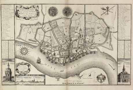
Ichnographia Burgi perantiqui Lennae regis in Agro Norfolciensi accurate delineata Ano...
Gulielmus RastrickAntike Landkarte von King's Lynn, Norfolk. Gedruckt in London im Jahre 1725.
Artikel-Nr. 10982
Beschreibung
Großer, seltener Stadtplan von King's Lynn
A large and detailed copper engraved plan of King's Lynn Harbour in Norfolk, drawn and published by Gulielmus Rastrick in 1725. Oriented with north to the left of the page.
With two decorative cartouches, two vignette illustrations of 'Porticus Nundinaria Lennensis' and 'Bursa Lennensis' in the lower corners, a compass rose, coat of arms, a mileage scale and a key in Latin and English from A to BB with important buildings and places, another key from 1 to 50 with street and bridge names, two medallions and a inset city view in the lower left corner.
We only could locate one copy of this separate published map in libraries world wide. It can be found in the Library of The Royal Society in UK.
Details
| Kartograph | Gulielmus Rastrick |
| Titel | Ichnographia Burgi perantiqui Lennae regis in Agro Norfolciensi accurate delineata Ano MDCCXXV. |
| Verlag, Jahr | London, 1725 |
| Bildgröße | 45.3 x 72.2 cm |
| Blattgröße | 53.0 x 74.6 cm |
Erhaltung
Spuren von zwei vertikalen und einer horizontalen Falte, ein kleiner Einriß in der Bugfalte hinterlegt. Sehr gute Erhaltung.
Bilder zum Herunterladen
Falls Sie die Bilder dieser Karte in einer Auflösung von 1200 Pixeln herunterladen möchten, folgen Sie bitte unten stehendem Verweis.
Sie können die Bilder auf Ihrer privaten oder kommerziellen Internetseite frei veröffentlichen, sofern Sie einen Verweis (Link) auf diese Webseite setzen. Falls Sie Fotos in höherer Auflösung benötigen, kontaktieren Sie uns bitte.
Gulielmus Rastrick: Ichnographia Burgi perantiqui Lennae regis in Agro Norfolciensi accurate delineata Ano MDCCXXV..
Antike Landkarte von King's Lynn, Norfolk. Gedruckt in London im Jahre 1725.
Britische Inseln - Rastrick, Gulielmus - Ichnographia Burgi perantiqui Lennae regis...

![[British Isles and England & Wales] [British Isles and England & Wales]](https://www.vintage-maps.com/2941-home_default/bordone-britische-inseln-england-und-wales-1528-1565.jpg)

![[The Firth of Murry] - To the Rt Hon.ble, my Lord Viscount Torbat, Lord Register of the Kingdom of Scotland [The Firth of Murry] - To the Rt Hon.ble, my Lord Viscount Torbat, Lord Register of the Kingdom of Scotland](https://www.vintage-maps.com/2244-home_default/collins-britische-inseln-schottland-nordsee-moray-firth-inverness.jpg)
