Produkt wurde in den Korb gelegt
Sie haben 0 Artikel in Ihrem Warenkorb. Es gibt 1 Artikel in Ihrem Warenkorb.
Gesamt Artikel
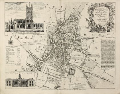
A Plan of Wolverhampton Surveyed in MDCCL By Isaac Taylor and Engraved by Thomas...
Thomas Jefferys (*1695 - †1771)Antike Landkarte von Wolverhampton, Staffordshire. Gedruckt bei Thomas Jefferys im Jahre 1751 in London.
Artikel-Nr. 10978
Beschreibung
Großer, seltener Stadtplan von Wolverhampton
A large and detailed copper engraved plan of Wolverhampton engraved and published by Thomas Jefferys in 1751 after a survey of Isaac Taylor in 1750. Oriented with north to the top of the page, the plan is dedicated by Jefferys to 'His Royal Highness the Prince of Wales'. A decorative title cartouche appears in the upper right corner, two large vignette illustrations of 'South Prospect of the Collegiate Church of St. Peters' and 'A Front View of the School' in the left corners, a description of the town and a list of the streets with number of houses and inhabitants. At the bottom of the plate the address of Jefferys: 'Publish'd according to Act of Parliament by Thos. Jefferys at the Corner at the Corner of St. Martin's Lane, Charing Cross London, Aprl. 8. 1751.'
This is first state of the map, printed and published just months after the survey as a separate map. We only could locate a handful of copies of this map in Libraries world wide.
Details
| Kartograph | Thomas Jefferys |
| Titel | A Plan of Wolverhampton Surveyed in MDCCL By Isaac Taylor and Engraved by Thomas Jefferys Geographer to His Royal Highness the Prince of Wales. |
| Verlag, Jahr | Thomas Jefferys, London, 1751 |
| Bildgröße | 49.0 x 61.2 cm |
| Blattgröße | 53.0 x 67.9 cm |
Erhaltung
Perfecter Zustand.
Kartograph
Thomas Jefferys war englischer Kartograph und Verleger. Er publizierte die besten Nordamerika- und Karibikkarten seiner Zeit. Jefferys verlegte auch englische Regionalkarten.
Bilder zum Herunterladen
Falls Sie die Bilder dieser Karte in einer Auflösung von 1200 Pixeln herunterladen möchten, folgen Sie bitte unten stehendem Verweis.
Sie können die Bilder auf Ihrer privaten oder kommerziellen Internetseite frei veröffentlichen, sofern Sie einen Verweis (Link) auf diese Webseite setzen. Falls Sie Fotos in höherer Auflösung benötigen, kontaktieren Sie uns bitte.
Thomas Jefferys: A Plan of Wolverhampton Surveyed in MDCCL By Isaac Taylor and Engraved by Thomas Jefferys Geographer to His Royal Highness....
Antike Landkarte von Wolverhampton, Staffordshire. Gedruckt bei Thomas Jefferys im Jahre 1751 in London.
Britische Inseln - Jefferys, Thomas - A Plan of Wolverhampton Surveyed in MDCCL...


![[British Isles and England & Wales] [British Isles and England & Wales]](https://www.vintage-maps.com/2941-home_default/bordone-britische-inseln-england-und-wales-1528-1565.jpg)

![[The Firth of Murry] - To the Rt Hon.ble, my Lord Viscount Torbat, Lord Register of the Kingdom of Scotland [The Firth of Murry] - To the Rt Hon.ble, my Lord Viscount Torbat, Lord Register of the Kingdom of Scotland](https://www.vintage-maps.com/2244-home_default/collins-britische-inseln-schottland-nordsee-moray-firth-inverness.jpg)
