Product successfully added to your shopping cart
There are 0 items in your cart. There is 1 item in your cart.
Antique Maps by Abraham Ortelius (*1527 - †1598)

Poloniae Finitimarumque Locorum Descriptio Auctore Wenceslao Godreccio Polono
Antwerp, 1584
Nice original old coloured map of Poland by Abraham Ortelius. Decorated with a sailing ship and a cartouche. From the 1584 Latin edition of Theatrum Orbis Terrarum , Latin text on verso.
Poloniae Finitimarumque Locorum Descriptio Auctore Wenceslao Godreccio...
1584 - Abraham Ortelius
11355Old coloured map of Poland. Printed in Antwerp in the year 1584.
Sold
Prussiae Regionis Sarmatiae Europeae Nobiliss. Vera et Nova Descriptio...
Antwerp, 1584
Nice original old coloured map of Prussia by Abraham Ortelius. Showing the Baltic Sea coastline from Danzig (Gdansk) to Konigsberg (Kaliningrad) to Memel (Klaipeda). Decorated with two galleon, a...
Prussiae Regionis Sarmatiae Europeae Nobiliss. Vera et Nova Descriptio...
1584 - Abraham Ortelius
11356Old coloured map of Gdansk, Kaliningrad, Konigsberg, Prussia. Printed in Antwerp in the year 1584.
Sold
Terra Sancta, a Petro Laicstain Perlustrata, et ab eius Ore et Schedis a Christiano Schrot in...
Antwerp, 1584
Nice original old coloured map of the Holy Land by Abraham Ortelius. Showing the coastal line from Beirut to Gaza. The title cartouche is surrounded by biblical vignettes. In the dramatic scene on...
Terra Sancta, a Petro Laicstain Perlustrata, et ab eius Ore et Schedis a...
1584 - Abraham Ortelius
11357Old coloured map of Palestine, Israel. Printed in Antwerp in the year 1584.
Sold
Ungariae Loca Praecipua Recens Emendata atque Edita, per Ioannem Sambucum Pannonium, Imp. Ms....
Antwerp, 1584
Nice original old coloured map of Hungary by Abraham Ortelius. Shows the region between Vienna, Budapest, Belgrade and Transylvania. Decorated with horses, cows and deer, a cartouche and a mileage...
Ungariae Loca Praecipua Recens Emendata atque Edita, per Ioannem...
1584 - Abraham Ortelius
11359Old coloured map of Transylvania. Printed in Antwerp in the year 1584.
Sold
Septentrionalium Regionum Descrip.
Antwerp, 1584
Fascinating and important map of the North Atlantic by A. Ortelius in stunning original colours.Showing Scandinavia, Siberia and the Arctic regions in the East, the British Isles with the...
Septentrionalium Regionum Descrip.
1584 - Abraham Ortelius
11436Old coloured map of the North Pole, North Atlantic. Printed in Antwerp in the year 1584.
Sold
Perusini Agri, Exactissima Novissimaque Descriptio: Auctore Egnatio Dante
Antwerp, 1584
Nice original old coloured map of Umbria with Perugia and the Lake Trasimeno by Abraham Ortelius. Decorated with a striking scrollwork cartouche and a compass rose. From the 1584 Latin edition of...
Perusini Agri, Exactissima Novissimaque Descriptio: Auctore Egnatio Dante
1584 - Abraham Ortelius
11437Old coloured map of the Lake Trasimeno, Perugia, Umbria. Printed in Antwerp in the year 1584.
Sold
Europae
C. Plantin, Antwerp, 1584
Beautiful old coloured map of Europe by Abraham Ortelius. Decorated with a sailing ship, compass rose and tents in Russia. The title cartouche shows Europa , the mother of King Minos of Crete,...
Europae
1584 - Abraham Ortelius
11743Old coloured map of the European continent. Printed in Antwerp by C. Plantin in 1584.
Sold![Ortelius, Italy, Sicily (Sicilia), 1584 [1624]: Siciliae Veteris Typus ...]( "Abraham Ortelius: Siciliae Veteris Typus ...")
Siciliae Veteris Typus ...
Balthasar Moretus, Antwerp, 1584 [1624]
One of the most beautiful maps of Sicily ever printed.A striking example of Ortelius' map of Sicily. Showing the Mediterranean island of Sicily (Sicilia) with three cartouches and rich...
Siciliae Veteris Typus ...
1584 - Abraham Ortelius
12688Coloured map of Sicily (Sicilia). Printed in Antwerp by Balthasar Moretus in 1624.
Sold
Septentrionalium Regionum Descrip.
Christoffel Plantin, Antwerp, 1587
Ortelius' famous and important map of the North Atlantic. With stunning old colours.The famous and probably the most beautiful map of the North. Shows the North Atlantic with Scandinavia and...
Septentrionalium Regionum Descrip.
1587 - Abraham Ortelius
12682Old coloured map of the North Pole, North Atlantic. Printed in Antwerp by Christoffel Plantin in 1587.
Sold
Westphaliae Totius, Finitimarumque Regionum Accurata Descriptio
A. Ortelius, Antwerp, 1588
Antique map of North Rhine-Westphalia and Lower Saxony by Abraham Ortelius. In the north with East Frisia, Oldenburg and Bremen, in the south to Duisburg, Dusseldorf and Cologne. Osnabrück is...
Westphaliae Totius, Finitimarumque Regionum Accurata Descriptio
1588 - Abraham Ortelius
11844Coloured map of North Rhine-Westphalia, Lower Saxony. Printed in Antwerp by A. Ortelius in 1588.
Sold
Illyricum
Christoffel Plantin, Antwerp, 1588
Old coloured antique map of the Western Balkans by Abraham Ortelius. Showing Croatia with Dalmatia, Slovenia, Bosnia and Herzegovina with the Adriatic Sea. In the north to Carinthia and Hungary...
Illyricum
1588 - Abraham Ortelius
12684Old coloured map of Croatia, Adriatic Sea, Western Balkans. Printed in Antwerp by Christoffel Plantin in 1588.
Sold
Argentoratensis agri descriptio
Antwerp, circa 1590
Beautiful original old coloured map of the Rhine river around Strasbourg by Abraham Ortelius. The map is based on the 1576 three sheet Elsas map by Daniel Specklin (Meurer p. 243-244).
Argentoratensis agri descriptio
1590 - Abraham Ortelius
10386Old coloured map of Strasbourg. Printed in Antwerp circa 1590.
Sold
Graecia, Sophiani
Antwerp, circa 1590
Colour copper engraved map of Greece with the Greek Islands, Crete, Asia Minor and the Aegean Sea. Latin text on verso.
Graecia, Sophiani
1590 - Abraham Ortelius
10552Coloured map of Asia Minor, Crete, Aegean, Peloponnese. Printed in Antwerp circa 1590.
Sold
Peregrinationis divi Pauli typus corographicus.
Antwerp, 1592
Hand coloured engraved map of the Eastern Mediterranean by Abraham Ortelius. Covering the Mediterranean Sea between Israel and Sicily with Cyprus, Italy, Greece and Turkey. With two biblical scenes...
Peregrinationis divi Pauli typus corographicus.
1592 - Abraham Ortelius
10850Coloured map of Israel, Greece, Turkey, Cyprus, Sicily. Printed in Antwerp in the year 1592.
Sold
Hellas. Graecia, Sophiani.
Antwerp, 1592
Coloured copper engraved map of Greece by A. Ortelius. Showing Greece with the Greek Islands, Crete, Asia Minor and the Aegean Sea. From the 1592 Latin edition of 'Theatrum Orbis Terrarum', Latin...
Hellas. Graecia, Sophiani.
1592 - Abraham Ortelius
10851Coloured map of Asia Minor, Crete, Aegean, Peloponnese. Printed in Antwerp in the year 1592.
Sold
Typus chorographicus, celebrium locorum in regno Iudae et Israhel
Antwerp, 1592
Beautiful coloured map of the Holy Land by A. Ortelius. The map is based on T. Stella's map of 1552, with two large Renaissance cartouches. From the 1592 Latin edition of 'Theatrum Orbis Terrarum'.
Typus chorographicus, celebrium locorum in regno Iudae et Israhel
1592 - Abraham Ortelius
10858Coloured map of Palestine, Israel. Printed in Antwerp in the year 1592.
Sold
Ducatus Mediolanensis, Finitimarumq Regionu Descriptio Auctore Iooanne Georgio Septala Mediolanense
Antwerp, 1592
Beautiful coloured map of northern Italy by A. Ortelius. Showing the area around Milan with Lago di Como, Genoa, Parma, Cremona and Bergamo. With a nice Renaissance cartouche, a sailing ship , a...
Ducatus Mediolanensis, Finitimarumq Regionu Descriptio Auctore Iooanne...
1592 - Abraham Ortelius
10866Coloured map of Milan, Milano. Printed in Antwerp in the year 1592.
Sold
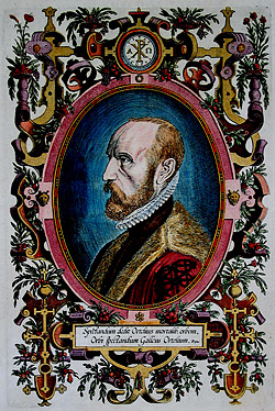
Spectandum Dedit Ortelius Mortalib. orbem Orbi Spectandum Galleus Ortelium. Papius
C. Planti, Antwerp, 1592
A beautiful coloured portrait of Abraham Ortelius as Frontispiece to his 'Theatrum Orbis'. Engraved by Phillipe Galle.
Spectandum Dedit Ortelius Mortalib. orbem Orbi Spectandum Galleus...
1592 - Abraham Ortelius
11069Copper engraving of a portrait. Abraham Ortelius. Printed in Antwerp by C. Planti in 1592.
Sold
Turingiae Noviss. Descript. per Iohannem Mellinger Halens / Misniae et Lusatiae Tabula Descripta...
A. Ortelius, Antwerp, 1592
Old coloured antique map of Saxony and Thuringia by A. Ortelius. Two maps on one sheet. The right map shows Saxony between Erfurt and Prague. With Dresden, Leipzig, Wittenberg, Görlitz, Weimar and...
Turingiae Noviss. Descript. per Iohannem Mellinger Halens / Misniae et...
1592 - Abraham Ortelius
11868Old coloured map of Saxony, Thuringia. Printed in Antwerp by A. Ortelius in 1592.
Sold
Germania.
Plantin, Antwerp, 1595
Beautiful hand colour copper engraved map of Germany by A. Ortelius. From the 1595 Latin edition of "Theatrum Orbis Terrarum".
Germania.
1595 - Abraham Ortelius
10625Coloured map of Germany. Printed in Antwerp by Plantin in 1595.
Sold
Natoliae, quae olim Asia Minor Nova Descriptio - Aegypti Recentior Descriptio - Carthaginis...
Antwerp, 1595
Coloured copper engraved map of Turkey by A. Ortelius. On right side a map of Egypt and one of Tunis. Three map on one sheet printed from one plate. From the 1595 Latin edition of 'Theatrum Orbis...
Natoliae, quae olim Asia Minor Nova Descriptio - Aegypti Recentior...
1595 - Abraham Ortelius
10854Coloured map of Tunis, Egypt, Cyprus, Turkey. Printed in Antwerp in the year 1595.
Sold
Thraciae veteris typus
Antwerp, 1595
Engraved map of the western part of Turkey by A. Ortelius. Showing the Dardanelles, the Sea of Marmara with the Bosporus and Istanbul. From the 1595 Latin edition of 'Theatrum Orbis Terrarum',...
Thraciae veteris typus
1595 - Abraham Ortelius
10861Antique map of the Sea of Marmara, Bosporus, Istanbul, Greece. Printed in Antwerp in the year 1595.
Sold![Ortelius, Atlas Parergon, 1595: Parergon, sive Veteris Geographiae aliquot Tabulae. [Bound with:] Nomenclator Ptolemaicus.]( "Abraham Ortelius: Parergon, sive Veteris Geographiae aliquot Tabulae. [Bound with:] Nomenclator Ptolemaicus.")
Parergon, sive Veteris Geographiae aliquot Tabulae. [Bound with:] Nomenclator Ptolemaicus.
Plantin, Antwerp, 1595
The Parergon maps began appearing as supplements within the Theatrum in 1579 with 3 maps. During the following years, more map were completed and the Parergon became an atlas in its own right. The...
Parergon, sive Veteris Geographiae aliquot Tabulae. [Bound with:]...
1595 - Abraham Ortelius
11259A splendid copy of Ortelius' Atlas of Ancient Geography. All maps and views finely coloured by a contemporary hand.
Sold
Graeciae Universae Secundum Hodiernum Situm Neoterica Descriptio
Antwerp, 1595
Beautiful original old coloured copper engraved map of Greece by A. Ortelius. Showing Greece with the Greek Islands, Crete, Asia Minor and the Aegean Sea. From the 1595 Latin edition of Theatrum...
Graeciae Universae Secundum Hodiernum Situm Neoterica Descriptio
1595 - Abraham Ortelius
11310Old coloured map of Asia Minor, Crete, Aegean, Peloponnese. Printed in Antwerp in the year 1595.
Sold


![Ortelius, Italy, Sicily (Sicilia), 1584 [1624]: Siciliae Veteris Typus ...](https://www.vintage-maps.com/3931-home_default/ortelius-italy-sicily-sicilia-1584-1624.jpg "Abraham Ortelius: Siciliae Veteris Typus ...")


![Ortelius, Atlas Parergon, 1595: Parergon, sive Veteris Geographiae aliquot Tabulae. [Bound with:] Nomenclator Ptolemaicus.](https://www.vintage-maps.com/1461-home_default/ortelius-atlas-parergon-1595.jpg "Abraham Ortelius: Parergon, sive Veteris Geographiae aliquot Tabulae. [Bound with:] Nomenclator Ptolemaicus.")
