Product successfully added to your shopping cart
There are 0 items in your cart. There is 1 item in your cart.
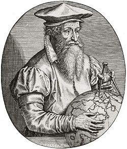
Antique Maps by Gerard Mercator (*1512 - †1594)

Alpinae seu Foederatae Rhaetiae Subditarumque ei Terrarum nova descriptio...
H. Hondius, Amsterdam, 1633
Beautiful antique map of Graubünden by G. Mercator. Showing north-east Switzerland with the Engadine, Bormio, Sargans, Bad Ragaz, Landquart, Chur, St. Moritz, Sils, Lake Como, parts of Vorarlberg...
Alpinae seu Foederatae Rhaetiae Subditarumque ei Terrarum nova...
1633 - Gerard Mercator
12955Antique map of Graubünden. Printed in Amsterdam by H. Hondius in 1633.
750,00 €
Argow
H. Hondius, Amsterdam, 1633
Beautiful antique map of Central Switzerland by G. Mercator. Shows central Switzerland around Lake Lucerne, Lake Zurich, Lake Walen and Lake Thun. With Zurich, Lucerne, Zug, Schwyz, Thun and Bern...
Argow
1633 - Gerard Mercator
12956Antique map of Aargau. Printed in Amsterdam by H. Hondius in 1633.
390,00 €
West Morlandia, Lancastria, Cestria, Caernaruan, Denbigh, Flint, Merionidh, Montgomery, Salopia,...
Jodocus Hondius, Amsterdam, 1634
Old coloured map of North Wales and the northwestern part of England by G. Mercator. Shows the north of Wales, the Isle of Man, Angelsey, Westmorland, Cheshire, Lancashire and Cumberland. With a...
West Morlandia, Lancastria, Cestria, Caernaruan, Denbigh, Flint,...
1634 - Gerard Mercator
12644Old coloured map of North West England, North Wales, Isle of Man. Printed in Amsterdam by Jodocus Hondius in 1634.
450,00 €
Atlantis Novi Pars Tertia, Italiam, Graeciam & maximas insula Maris Mediterranei ...
Jodocus Hondius, Amsterdam, 1638
Title page from the second volume of the Mercator-Hondius Atlas, published 1638 in Amsterdam.
Atlantis Novi Pars Tertia, Italiam, Graeciam & maximas insula Maris...
1638 - Gerard Mercator
12717Title page of the Mercator-Hondius Atlas. Printed in Amsterdam in 1638.
290,00 €
Palatinatus Bavariae
J. Janssonius, Amsterdam, 1653-66
Antique map of the Upper Palatinate (Bavaria) by Gerard Mercator. Shows the north of Bavaria between Nuremberg, Ingolstadt, Furth and Neuhaus. With Regensburg, Neumarkt, Amberg and Straubing....
Palatinatus Bavariae
1653 - Gerard Mercator
12948Coloured map of Upper Palatinate. Printed in Amsterdam by J. Janssonius in 1653.
390,00 €
Germania
Rumold Mercator, Duisburg, 1585 or 1595
Early and rare old coloured map of Germany by Gerard Mercator. From the first edition of his famous Atlas sive Cosmographicae Meditationes de Fabrica Mundi et Fabricati Figura published in...
Germania
1585 - Gerard Mercator
11902Old coloured map of Germany. Printed in Duisburg by Rumold Mercator in 1585 or 1595.
Sold
Graecia
Gerard Mercator, Duisburg, 1589
True first edition of Mercator's map of Greece with beautiful old colour.Early and important map of Greece with stunning original colour. This is the real first edition published in 1589...
Graecia
1589 - Gerard Mercator
11497Old coloured map of Asia Minor, Aegean, Peloponnese. Printed in Duisburg by Gerard Mercator in 1589.
Sold
Italia
Gerard Mercator, Duisburg, 1589
True first edition of Mercator's map of Italy with beautiful old colour.Early and important engraved map of Italy with Sardinia and Corsica. This is the real first edition, published in 1589...
Italia
1589 - Gerard Mercator
11498Old coloured map of Italy. Printed in Duisburg by Gerard Mercator in 1589.
Sold
Morea olim Peloponnesus
1590
Coloured engraving showing Greek peninsula Peloponnes (Pelopónnisos) former Morea. From a french edition.
Morea olim Peloponnesus
1590 - Gerard Mercator
10032Coloured map of the Peloponnese. Printed in the year 1590.
Sold
Alsatia inferior
G. Mercator, Amsterdam, circa 1595
Nice coloured map of the Alsace from G. Mercator. Covering the area around Strasbourg.
Alsatia inferior
1595 - Gerard Mercator
10501Coloured map of Strasbourg, Alsace. Printed in Amsterdam by G. Mercator circa 1595.
Sold
Sardina
G. Mercator, Basle, 1595
First edition of Mercator's map of Sardinia, published 1595. The later editions have a different title and cartouche.
Sardina
1595 - Gerard Mercator
11440Old coloured map of Sardinia. Printed in Basle by G. Mercator in 1595.
Sold
Irlandiae Regnum
Amsterdam, 1595 (1628)
Hand coloured map of Ireland by G. Mercator. Oriented to the West. Decorative title cartouche. French text on verso.
Irlandiae Regnum
1595 - Gerard Mercator
11446Original antique map of Irland. Printed in Amsterdam in 1628.
Sold
Morea olim Peloponnesus
Amsterdam, 1595 (1630)
Beautiful original old coloured engraved map of the Peloponnes (Pelopónnisos) formerly Morea by G. Mercator. From the 1630 Latin edition of the Mercator-Hondius Atlas.
Morea olim Peloponnesus
1595 - Gerard Mercator
11450Old coloured map of the Peloponnese. Printed in Amsterdam in 1630.
Sold
Helvetia cum Finitimis Regionibus Confoederatis
Rumold Mercator, Duisburg, 1595
Early map of Switzerland by Gerard Mercator. From the first edition of his famous Atlas sive Cosmographicae Meditationes de Fabrica Mundi et Fabricati Figura published in Duisburg in 1595 by his...
Helvetia cum Finitimis Regionibus Confoederatis
1595 - Gerard Mercator
11499Old coloured map of Switzerland. Printed in Duisburg by Rumold Mercator in 1595.
Sold
Fionia
G. Mercator, Duisburg, 1595 or 1602
Old coloured antique map of the eastern part of South Denmark by Gerard Mercator. With Funen (Fyn) and the offshore islands Langeland and Ærø. Below a title cartouche. From the early Latin edition...
Fionia
1595 - Gerard Mercator
11860Old coloured map of Fyn. Printed in Duisburg by G. Mercator in 1595 or 1602.
Sold
Chorographica Tabula Lacus Lemanni Locorumque Circumiacentium Auctore Iac. G. Genevensi
H. Hondius, Amsterdam, 1606
Beautiful old coloured map of the Lake Geneva after J. Goulart from the first Latin edition of the Mercator-Hondius Atlas. Rare edition with the five portraits of Calvin, Farellus, Viretus, Beza...
Chorographica Tabula Lacus Lemanni Locorumque Circumiacentium Auctore...
1606 - Gerard Mercator
10657Antique map of the Lake Geneva. Printed in Amsterdam by H. Hondius in 1606.
Sold
India Orientalis
H. Hondius, Amsterdam, circa 1606
Beautiful coloured map of India, the Malay Peninsula, China and the Philippines, Thailand and Cambodia and parts of Sumatra with Borneo from a French edition of the Mercator-Hondius Atlas. With two...
India Orientalis
1606 - Gerard Mercator
10687Coloured map of the Philippines, Thailand, China, India. Printed in Amsterdam by H. Hondius circa 1606.
Sold
Atlas minor à I.Hondio plurimis aeneis tabulis auctus atque illustratus.
J. Hondius, C. Claesz, J. Janssonius, Amsterdam, 1607
Rare First Edition of the Atlas Minor by Mercator. With 153 Maps.A complete and well preserved example of the rare first edition of Mercator's Atlas Minor .In 1607, Jodocus Hondius...
Atlas minor à I.Hondio plurimis aeneis tabulis auctus atque illustratus.
1607 - Gerard Mercator
12787Atlas Minor by G. Mercator with 153 copper engraved maps, publihed by J. Hondius and J. Janssonius 1607 in Amsterdam.
Sold
Burgundia superior sive liber comitatus
Amsterdam, circa 1610
Beautiful coloured engraved map the Burgundy (Bourgogne) with parts of Switzerland and France by G. Mercator. Showing the Lake Geneva or Lake Léman and the Lake Neuchâtel. From a Latin edition of...
Burgundia superior sive liber comitatus
1610 - Gerard Mercator
10586Coloured map of the Burgundy. Printed in Amsterdam circa 1610.
Sold
Asia ex Magna Orbis Terre Descriptione Gerardi Mercatoris Desumpta, Studio et Industria G.M....
H. Hondius, Amsterdam, circa 1613
Beautiful original old coloured Mercator map of Asia. This map first appeared in the famous Mercator "Atlas Sive Cosmographicae" of 1595, later published until 1633 in Mercator Hondius Atlases....
Asia ex Magna Orbis Terre Descriptione Gerardi Mercatoris Desumpta,...
1613 - Gerard Mercator
10322Old coloured map of the Asian continent. Printed in Amsterdam by H. Hondius circa 1613.
Sold
Tavrica Chersonesvs Nostra aetate Przecopsca et Gazara dicitur
H. Hondius, Amsterdam, circa 1613
Beautiful original old coloured Mercator map of The Ukraine with Crimean peninsula, including the northern part of the Black Sea and up to Smolensk in the North. This map comes from an English...
Tavrica Chersonesvs Nostra aetate Przecopsca et Gazara dicitur
1613 - Gerard Mercator
10324Old coloured map of the Crimean Peninsula, Ukraine. Printed in Amsterdam by H. Hondius circa 1613.
Sold
Daniae Regnu
J. Hondius, Amsterdam, 1613-19
Old coloured antique map of Denmark by Gerard Mercator. Shows Denmark with Holstein and Mecklenburg with Rügen in the south and south Sweden in the north. Top right a title cartouche, in the North...
Daniae Regnu
1613 - Gerard Mercator
11863Old coloured map of Denmark. Printed in Amsterdam by J. Hondius in 1613.
Sold
Septentrionalium Terrarum Descriptio
Jodocus Hondius, Amsterdam, 1613
The First Separate Printed Map of the North Pole and the Arctic Regions.The first printed map devoted exclusively to the Arctic. First published after Gerard Mercator's death (1594) by his...
Septentrionalium Terrarum Descriptio
1613 - Gerard Mercator
12431Antique map of the North Pole and the Arctic. Printed in Amsterdam by Jodocus Hondius in 1613.
Sold
Cornubia, Devonia, Somersetus, Dorcestria, Wiltonia, Glocestria Monumetha, Glamorgan, Caermarden,...
Amsterdam, 1619
Original coloured map of south west England and south Wales of Gerard Mercator. From a latin edition of the Mercator Hondius Atlases.
Cornubia, Devonia, Somersetus, Dorcestria, Wiltonia, Glocestria...
1619 - Gerard Mercator
10160Old coloured map of South Wales, South West England. Printed in Amsterdam in the year 1619.
Sold


