Product successfully added to your shopping cart
There are 0 items in your cart. There is 1 item in your cart.
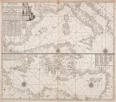
Nouvelle carte reduite de la Mediterranee - Nieuwe Wassende Graadege Pas-kaart van de...
Johannes Loots (*1665 - †1726)Reference 12615
Description
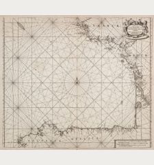
Very rare nautical chart of the Mediterranean Sea by Johannes Loots. Above the western part of the Mediterranean with the coasts of Spain, France, Italy, the Balkans and the northwestern part of Africa. Below, the eastern Mediterranean with Greece, Turkey, Syria, Lebanon, Israel and Egypt. With the Balearic Islands, Corsica, Sardinia, Sicily, Malta and Cyprus. To the upper left a title cartouche, below a key with 104 Mediterranean islands. In the eastern part a mileage scale and another key with 58 islands. Four compass roses surrounded by rhumb lines.
The title mentions Claas de Vries (a surveyor and cartographer) with whom Loots was in partnership together with Antoni de Winter (engraver) between 1695 and 1698. This Mediterranean map was published in a similar form by Johannes van Keulen with different cartouches and two compass roses. However, the van Keulen map is more commonly found.
Old doubled on blue paper. Nautical charts not bound in atlases and intended for navigation at sea were often reinforced with a second sheet, as seen here. This made them easier to handle and a suitable set of different maps could be taken along on the planned voyage.
Rarity:
All sea charts by Johannes Loots are extremely rare, as they were mostly sold as single sheets and used for navigation at sea. Usually, antique maps are preserved over the centuries only if they were protected and bound in a book or atlas. Only a few atlases by Johannes Loots are known, one with 14 nautical charts is hold by the Library of Congress, Washington. This map of the Mediterranean offered here is also bound into this sea atlas: https://www.loc.gov/item/2011586011/
Until 2011, only 5 charts by Johannes Loots were listed in the AMPR. For comparison: 720 charts by Johannes van Keulen can be found in the AMPR.
The example of this chart of the Mediterranean from the Library of Congress, apart from the one offered here, is the only one worldwide we could locate. Neither in the trade of the past 40 years nor in other public collections this sea chart by Loots can be found.
Details
| Cartographer | Johannes Loots |
| Title | Nouvelle carte reduite de la Mediterranee - Nieuwe Wassende Graadege Pas-kaart van de Geheele Middelansche Zee... Claas de Vries |
| Publisher, Year | Johannes Loots, Amsterdam, 1715 |
| Plate Size | 52.0 x 59.5 cm (20.5 x 23.4 inches) |
| Sheet Size | 54.0 x 61.7 cm (21.3 x 24.3 inches) |
Condition
Cartographer
Images to Download
If you like to download the image of this map with a resolution of 1200 pixels, please follow the link below.
You can use this image for publication on your personal or commercial websites for free if you set a link to this website. If you need photographs with a higher resolution, please contact us.
Mediterranean - Loots, Johannes - Nouvelle carte reduite de la Mediterranee...

![[Map of Europe] [Map of Europe]](https://www.vintage-maps.com/2931-home_default/bordone-europe-continent-1528-1565.jpg)
![[Candia, Crete, Karpathos] [Candia, Crete, Karpathos]](https://www.vintage-maps.com/2939-home_default/bordone-greece-crete-and-karpathos-1528-1565.jpg)
![[Euboea, Negroponte, Bosporus, Istanbul] [Euboea, Negroponte, Bosporus, Istanbul]](https://www.vintage-maps.com/2937-home_default/bordone-greece-negroponte-euboea-1528-1565.jpg)
