Product successfully added to your shopping cart
There are 0 items in your cart. There is 1 item in your cart.
Total products
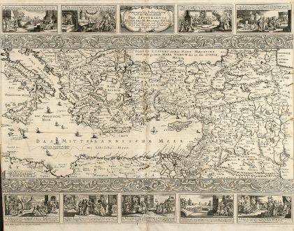
Geographische Beschreibung von der Wanderschaft der Apostelen und Reisen des H....
AnonymousAntique map of the Holy Land. Printed in Minden by Johann Detleffsen in 1716.
Reference 10505
Description
Rare anonymous map of the eastern Mediterranean after a almost identical N. Visscher map from 1657. With 9 small vignettes view showing the life and travels of St. Paul. From a German bible printed in Minden by Johann Detleffsen in 1716.
Details
| Cartographer | Anonymous |
| Title | Geographische Beschreibung von der Wanderschaft der Apostelen und Reisen des H. Apostels Pauli |
| Publisher, Year | Johann Detleffsen, Minden, 1716 |
| Plate Size | 35.6 x 47.3 cm (14.0 x 18.6 inches) |
| Sheet Size | 40.5 x 47.7 cm (15.9 x 18.8 inches) |
Condition
Centerfold backed, some creases on left side and around centerfold, small left and right margin.
Images to Download
If you like to download the image of this map with a resolution of 1200 pixels, please follow the link below.
You can use this image for publication on your personal or commercial websites for free if you set a link to this website. If you need photographs with a higher resolution, please contact us.
Anonymous: Geographische Beschreibung von der Wanderschaft der Apostelen und Reisen des H. Apostels Pauli.
Antique map of the Holy Land. Printed in Minden by Johann Detleffsen in 1716.
Mediterranean - Anonymous - Geographische Beschreibung von der...

![[Map of Europe] [Map of Europe]](https://www.vintage-maps.com/2931-home_default/bordone-europe-continent-1528-1565.jpg)
![[Candia, Crete, Karpathos] [Candia, Crete, Karpathos]](https://www.vintage-maps.com/2939-home_default/bordone-greece-crete-and-karpathos-1528-1565.jpg)
![[Euboea, Negroponte, Bosporus, Istanbul] [Euboea, Negroponte, Bosporus, Istanbul]](https://www.vintage-maps.com/2937-home_default/bordone-greece-negroponte-euboea-1528-1565.jpg)
![Ch'onha chido [Atlas of all under Heaven] Ch'onha chido [Atlas of all under Heaven]](https://www.vintage-maps.com/3314-home_default/anonymous-korean-woodblock-atlas-chonha-chido-1750.jpg)
![Ch'onha Chido [Atlas of all under Heaven] Ch'onha Chido [Atlas of all under Heaven]](https://www.vintage-maps.com/3336-home_default/anonymous-korean-manuscript-atlas-chonha-chido-1820.jpg)
![Ch'onha Chido [Atlas of all under Heaven] Ch'onha Chido [Atlas of all under Heaven]](https://www.vintage-maps.com/4291-home_default/anonymous-korean-manuscript-atlas-chonha-chido-1800.jpg)
