Product successfully added to your shopping cart
There are 0 items in your cart. There is 1 item in your cart.
Total products
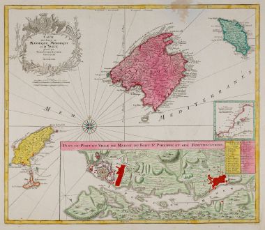
Carte des Isles de Maiorque Minorque et d' Yvice
Tobias Conrad Lotter (*1717 - †1777)Old coloured map of Ibiza, Menorca, Mallorca, Baleares. Printed in Augsburg by T. C. Lotter circa 1760.
Reference 12090
Description
Old coloured map of the Balearic Islands with Mallorca, Menorca and Ibiza by Tobias Lotter. To the right a small inset map of the western Mediterranean Sea, below a detailed plan of the port of Mahón on Menorca with the title Plan du Port et Ville de Mahon du Fort St. Philippe et ses Fortifications, top left a title cartouche.
Details
| Cartographer | Tobias Conrad Lotter |
| Title | Carte des Isles de Maiorque Minorque et d' Yvice |
| Publisher, Year | T. C. Lotter, Augsburg, circa 1760 |
| Plate Size | 48.2 x 56.2 cm (19.0 x 22.1 inches) |
| Sheet Size | 54.0 x 64.0 cm (21.3 x 25.2 inches) |
Condition
A brown spot to the upper right.
Cartographer
Tobias Lotter was born 1717 in Germany. He became a publisher and engraver in Augsburg. He was engaged by Matthäus Seutter the elder as an engraver and married his daughter. He also was successful with his own business and became one of the better known German cartographers. After his death in 1777, the business was continued by his son Matthias Albrecht Lotter.
Images to Download
If you like to download the image of this map with a resolution of 1200 pixels, please follow the link below.
You can use this image for publication on your personal or commercial websites for free if you set a link to this website. If you need photographs with a higher resolution, please contact us.
Tobias Conrad Lotter: Carte des Isles de Maiorque Minorque et d' Yvice.
Old coloured map of Ibiza, Menorca, Mallorca, Baleares. Printed in Augsburg by T. C. Lotter circa 1760.
Spain - Portugal - Lotter, Tobias Conrad - Carte des Isles de Maiorque Minorque et d'...

![Tabula nova Hispaniae [Tabula noua Hispaniae] Tabula nova Hispaniae [Tabula noua Hispaniae]](https://www.vintage-maps.com/3236-home_default/fries-spain-portugal-1541.jpg)

![[Canary Islands] [Canary Islands]](https://www.vintage-maps.com/3021-home_default/bordone-spain-portugal-canaries-tenerife-gran-canaria.jpg)
