Product successfully added to your shopping cart
There are 0 items in your cart. There is 1 item in your cart.
Germaniae nova et accurata descriptio - Germania
Jodocus Hondius (*1563 - †1612)Reference 12655
Description
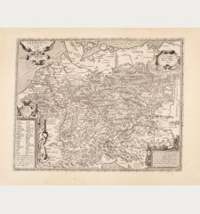
Scarce Visscher-Hondius map of the Holy Roman Empire with side panels.
Very decorative and rare 'carte-à-figures' map of Germany with the surrounding countries by Jodocus Hondius. This beautiful map of Germany is based on a map by C. J. Visscher from 1621 and was first published in 1625. Shortly after the death of Jodocus Hondius II, the copper plate came into the possession of Everard Cloppenburg, who published the map with a changed publisher's address and date as a broadsheet, but also in the work Historis oft Waerachtich verhael van Oorlooge in Duytschland. Where also this example comes from, dated 1630 next to the title cartouche. Two later editions were published by D. Danckerts and F. de Wit.
The map is surrounded on all sides by figures, city views and coats of arms. The upper border shows the title Germania and the imperial coat of arms in the centre. Next to it the equestrian portraits of the emperor and the seven electors. At the bottom a series of ten city views, each with four coats of arms: Frankfurt, Augsburg, Metz, Leipzig, Strasbourg, Lübeck, Heidelberg, Brunswick, Trier and Hamburg. On the left margin three costumed figures and the city views of Prague, Spiers, Nuremberg and Basel. On the right margin three figures with the city views of Cologne, Vienna, Regensburg and Ulm. At the lower left a beautiful title cartouche, in the North Sea a compass rose.
Details
| Cartographer | Jodocus Hondius |
| Title | Germaniae nova et accurata descriptio - Germania |
| Publisher, Year | Everard Cloppenburgh, Amsterdam, 1625 [1630] |
| Plate Size | 45.4 x 55.6 cm (17.9 x 21.9 inches) |
| Sheet Size | 47.2 x 57.5 cm (18.6 x 22.6 inches) |
| Reference | Schilder, G.: Monumenta Cartographica Neerlandica VI, 37.2 |
Condition
Cartographer
Images to Download
If you like to download the image of this map with a resolution of 1200 pixels, please follow the link below.
You can use this image for publication on your personal or commercial websites for free if you set a link to this website. If you need photographs with a higher resolution, please contact us.
Germany - Hondius, Jodocus - Germaniae nova et accurata descriptio -...

![Jodocus Hondius: Germaniae nova et accurata descriptio - Germania Antique Maps, Hondius, Germany, Germany, 1625 [1630]: Germaniae nova et accurata descriptio - Germania](https://www.vintage-maps.com/4048-large_default/hondius-germany-germany-1625-1630.jpg)


![[De Boemia. / Tabula quarta & quinta Europae de nonnullis / Germaniae ...] [De Boemia. / Tabula quarta & quinta Europae de nonnullis / Germaniae ...]](https://www.vintage-maps.com/2304-home_default/fries-germany-1541.jpg)
