Product successfully added to your shopping cart
There are 0 items in your cart. There is 1 item in your cart.
Total products
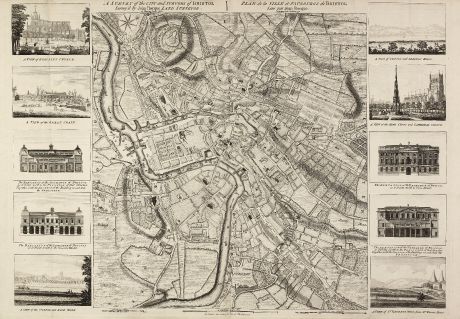
A Survey of the City and Suburbs of Bristol Survey'd by John Rocque Land Surveyor at...
John Rocque (*1704 - †1762)Antique map of Bristol. Printed in London by J. Rocque in 1750.
Reference 10983
Description
Rare map of Bristol by J. Rocque
A large and detailed copper engraved map of the city and suburbs of Bristol, draw, serveyed and published by John Rocque in 1750. Surrounded by 10 view: A view of Redcliff Church on the south side with part of church yard -- A view of the Great Crain and Slip at the lower end of Princess Street -- The elevation of the Exchange of Bristol as it fronts north to the Peristyle... -- The elevation of the Exchange of Bristol as it fronts to the General Market ... -- Cathedral or the view of the college and rope walk from the opposite south side of the River Avon -- A view of Clifton and Brandon Hills from the south side of the River Avon -- A view of the High Cross and Cathedral Church from the north side of College Green -- The elevation of the Exchange of Bristol as it fronts north to Corn Street -- The elevation of the Exchange of Bristol as it fronts south to the Peristyle -- A view of St. Vincents Rocks with the Hot Well's from Mr Warrens House.
This is first state of the map, printed and published separately 1750 by Rocque itself. We only could locate a handful of copies of this separate published map in libraries world wide.
Details
| Cartographer | John Rocque |
| Title | A Survey of the City and Suburbs of Bristol Survey'd by John Rocque Land Surveyor at Charing Cross, 1750 / Plan de la Ville et Faubourgs de Bristol Leve par Jean Rocque a Charing Cross a Londres 1750. |
| Publisher, Year | J. Rocque, London, 1750 |
| Plate Size | 51.3 x 70.9 cm (20.2 x 27.9 inches) |
| Sheet Size | 53.0 x 76.5 cm (20.9 x 30.1 inches) |
| Reference | Map Forum Issue 5, The Works of John Rocque #50 |
Condition
Evidence of two vertical old folds, very good condition. It is quite unusual to find a separate published map in such preservation.
Cartographer
John Rocque was an English engraver, active in London from 1734. He is best known for a 24-sheet plan of London published in 1746.
Images to Download
If you like to download the image of this map with a resolution of 1200 pixels, please follow the link below.
You can use this image for publication on your personal or commercial websites for free if you set a link to this website. If you need photographs with a higher resolution, please contact us.
John Rocque: A Survey of the City and Suburbs of Bristol Survey'd by John Rocque Land Surveyor at Charing Cross, 1750 / Plan de la Ville....
Antique map of Bristol. Printed in London by J. Rocque in 1750.
British Isles - Rocque, John - A Survey of the City and Suburbs of...


![[British Isles and England & Wales] [British Isles and England & Wales]](https://www.vintage-maps.com/2941-home_default/bordone-british-isles-england-and-wales-1528-1565.jpg)
![[The Firth of Murry] - To the Rt Hon.ble, my Lord Viscount Torbat, Lord Register of the Kingdom of Scotland [The Firth of Murry] - To the Rt Hon.ble, my Lord Viscount Torbat, Lord Register of the Kingdom of Scotland](https://www.vintage-maps.com/2244-home_default/collins-scotland-north-sea-moray-firth-inverness.jpg)
