Product successfully added to your shopping cart
There are 0 items in your cart. There is 1 item in your cart.
Curiosities
- 1
- 2

Tafel in welcher alle gehörige Werck-zeuge zur Kriegs-Kunst, Vestungs-bau und Artillerie, zu...
J. B. Homann, Nuremberg, circa 1720
Large, old coloured engraving with numerous illustrations of siege and war technology by Johann Baptist Homann. Including different military equipment such as cannons, mortars, battle axes, various...
Tafel in welcher alle gehörige Werck-zeuge zur Kriegs-Kunst,...
1720 - Johann Baptist Homann
12591Copper engraving of a military scene. Printed in Nuremberg by J. B. Homann circa 1720.
Sold
Neue Tafel vor alle Liebhabers und See-fahrende Personen Stellet vor ein Orlog oder Kriegs-Schiff...
J. B. Homann, Nuremberg, circa 1720
Large, old coloured engraving of a warship by Johann Baptist Homann. Published around 1720 in Nuremberg. Shows a three-master battleship with dinghies in the centre, below the cross section of the...
Neue Tafel vor alle Liebhabers und See-fahrende Personen Stellet vor ein...
1720 - Johann Baptist Homann
12675Copper engraving of a maritim scenery. Warship. Printed in Nuremberg by J. B. Homann circa 1720.
Sold
Tafel in welcher alle gehörige Werck-zeuge zur Kriegs-Kunst, Vestungs-bau und Artillerie, zu...
J. B. Homann, Nuremberg, circa 1720
Large, old coloured engraving with numerous illustrations of siege and war technology by Johann Baptist Homann. Including different military equipment such as cannons, mortars, battle axes, various...
Tafel in welcher alle gehörige Werck-zeuge zur Kriegs-Kunst,...
1720 - Johann Baptist Homann
12751Copper engraving of a military scene. Printed in Nuremberg by J. B. Homann circa 1720.
Sold
Accurata Utopiae Tabula das ist der Neu-Entdeckten Schalck-Welt, oder des so Offt Benannten und...
G. M. Seutter, Augsburg, circa 1730
The famous fantasy map of Utopia.Schlaraffenland stand for the Land of Cockaigne in German and represents a country of idleness and luxury. This is a totally imaginary map, but...
Accurata Utopiae Tabula das ist der Neu-Entdeckten Schalck-Welt, oder...
1730 - George Matthäus Seutter
11487Old coloured map of Cockaigne, Utopia. Printed in Augsburg by G. M. Seutter circa 1730.
Sold
Symbolische Sinnreiche in einer Belagerung... Versuchungen der Liebe... Representation symbolique...
G. M. Seutter, Augsburg, circa 1740
Seutter's famous allegorical map representing the battle of the sexes and of love. In style of a typical 18th century battle plan.Jeffrey N. Peters describes this map in The History of...
Symbolische Sinnreiche in einer Belagerung... Versuchungen der Liebe......
1740 - George Matthäus Seutter
12420Fantasy map by G. M. Seutter, printed in Ausburg around 1740.
Sold
A Circle of Winds consisting of 32 points commonly called the Mariners Compass / Artificial Sphere
E. Bowen, London, 1747
Two engravings printed from one plate on one sheet. The left side shows a compass rose with 32 wind directions, the right shows an armillary sphere. Both images have cherubs with navigational...
A Circle of Winds consisting of 32 points commonly called the Mariners...
1747 - Emanuel Bowen
11280Engraving of a compass rose and an armillary sphere. Published by E. Bowen in London during the year 1747.
Sold
The Solar System, with the Orbit of 5 remarkable Comets.
E. Bowen, London, 1747
Fascinating model of the solar system out to Saturn. Showing the orbits of 5 comets, the date the comets first appeared, the period and a prediction on the next appearance. One comet out of the...
The Solar System, with the Orbit of 5 remarkable Comets.
1747 - Emanuel Bowen
11281Engraving of the solar system with comets. Published by E. Bowen in London in 1747.
Sold
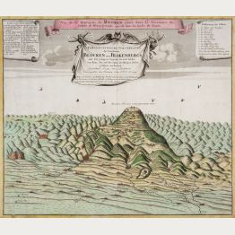
Perspectivische Vorstellung des berühmten Blocken oder Blokenbergs... 1732... 1749 / Vue de la...
Homann Erben, Nuremberg, 1749
Rare and sought-after engraving with the view of the Brocken in the Harz Mountains with witches and demons circling in the sky. This is the first edition, still without the additional explanation...
Perspectivische Vorstellung des berühmten Blocken oder Blokenbergs......
1749 - Homann Erben
12474Old coloured map of the Brocken with witches. Printed in Nuremberg by Homann Erben in 1749.
Sold
Germaniae Aliorumque Quorundam Loco-rum Europae Poliometria
circa 1750
Distance table from L.C. Lotter, with nice cartouche and explanation of usage.
Germaniae Aliorumque Quorundam Loco-rum Europae Poliometria
1750 - Tobias Conrad Lotter
10066Old coloured distance chart. Printed circa 1750.
Sold
Tabula Anemographica seu Pyxis Nautica, vulgo Compass Charte
T. C. Lotter, Augsburg, circa 1760
Wind map in stile of a wind rose. Original old colouring by the publisher.
Tabula Anemographica seu Pyxis Nautica, vulgo Compass Charte
1760 - George Matthäus Seutter
10298Old coloured wind map. Printed in Augsburg by T. C. Lotter circa 1760.
Sold
Atlas
Paris, circa 1820
A boxed set of 8 jigsaw puzzles published around 1820 by Hyacinthe Langlois. A wonderful example of an early nineteenth century French educational tool for teaching geography to young children....
Atlas
1820 - Hyacinthe Langlois
11223Old coloured jigsaw puzzles. Printed in Paris in the year 1820.
Sold
Mappemonde en deux Hemispheres
Paris, circa 1880
Appealing cartographical toy, consisting of 20 wooden cubes, each side of each cube with a map section pasted on, thus forming 6 puzzle maps of the world, Europe, Asia, Africa, the Americas and...
Mappemonde en deux Hemispheres
1880 - Charles Verneau
11309Cartographical toy consisting of 20 wooden cubes. Fabricated in Paris during the year 1880.
Sold
Humoristische Landkarte
Verlag Hermann Bercker, Munich, 1914
Comic map on a postcard with war propaganda published during the first months of World War I.
Humoristische Landkarte
1914 - Anonymous
11513Map of World War One, Propaganda Map. Printed in Munich by Verlag Hermann Bercker in 1914.
Sold


- 1
- 2