Product successfully added to your shopping cart
There are 0 items in your cart. There is 1 item in your cart.
Total products
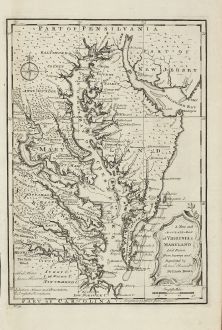
A New and Accurate Map of Virginia & Maryland. Laid Down from Surveys and Regulated by...
Emanuel Bowen (*1693 - †1767)Antique map of Maryland, Virginia. Printed in London by E. Bowen in 1747.
Reference 11030
Description
Scarce map of the Chesapeake region by Bowen from 'A Complete System of Geography'. Based on Hermann's map of 1673 and Popple's map of 1733. Showing numerous early towns and villages includes interesting annotations and place names.
Details
| Cartographer | Emanuel Bowen |
| Title | A New and Accurate Map of Virginia & Maryland. Laid Down from Surveys and Regulated by Astronl. Observatns. |
| Publisher, Year | E. Bowen, London, 1747 |
| Plate Size | 33.2 x 22.9 cm (13.1 x 9.0 inches) |
| Sheet Size | 42.7 x 25.7 cm (16.8 x 10.1 inches) |
Condition
Excellent condition.
Cartographer
Emanuel Bowen was a printer, publisher and map engraver in London during the mid-eighteenth century. From 1714 onwards he worked in London and began to produce some of the finest and most attractive maps of the century.
Images to Download
If you like to download the image of this map with a resolution of 1200 pixels, please follow the link below.
You can use this image for publication on your personal or commercial websites for free if you set a link to this website. If you need photographs with a higher resolution, please contact us.
Emanuel Bowen: A New and Accurate Map of Virginia & Maryland. Laid Down from Surveys and Regulated by Astronl. Observatns..
Antique map of Maryland, Virginia. Printed in London by E. Bowen in 1747.
North America - Bowen, Emanuel - A New and Accurate Map of Virginia &...

