Product successfully added to your shopping cart
There are 0 items in your cart. There is 1 item in your cart.
Total products
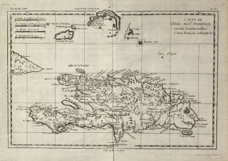
Carte de l'Isle de St. Domingue une des Grandes Antilles, Colonic Francoise et Espagnole.
Rigobert Bonne (*1729 - †1795)Antique map of Haiti, Dominican Republic. Printed in Paris in the year 1774.
Reference 11271
Description
Engraved map of the Caribbean Island of Hispaniola by Rigobert Bonne. Containing the two sovereign states of the Dominican Republic and Haiti. With surrounding islands and the western part of Cuba.
Details
| Cartographer | Rigobert Bonne |
| Title | Carte de l'Isle de St. Domingue une des Grandes Antilles, Colonic Francoise et Espagnole. |
| Publisher, Year | Paris, 1774 |
| Plate Size | 21.7 x 31.8 cm (8.5 x 12.5 inches) |
| Sheet Size | 25.0 x 35.7 cm (9.8 x 14.1 inches) |
Condition
Very good condition.
Cartographer
Rigobert Bonne, born 1729 in Raucourt, was a French hydrographer and cartographer mainly publishing sea charts. His major work was the Atlas Maritime first published in 1762. He died in 1795.
Images to Download
If you like to download the image of this map with a resolution of 1200 pixels, please follow the link below.
You can use this image for publication on your personal or commercial websites for free if you set a link to this website. If you need photographs with a higher resolution, please contact us.
Rigobert Bonne: Carte de l'Isle de St. Domingue une des Grandes Antilles, Colonic Francoise et Espagnole..
Antique map of Haiti, Dominican Republic. Printed in Paris in the year 1774.
Central America - Caribbean - Bonne, Rigobert - Carte de l'Isle de St. Domingue une des...

![[West Indies, Jamaica, Hispaniola and South America] [West Indies, Jamaica, Hispaniola and South America]](https://www.vintage-maps.com/3035-home_default/bordone-central-america-caribbean-jamaica-hispaniola.jpg)
![[Lesser Antilles, West Indies] Guadalupe, Dominica, Matinina [Lesser Antilles, West Indies] Guadalupe, Dominica, Matinina](https://www.vintage-maps.com/3027-home_default/bordone-central-america-caribbean-guadeloupe-martinique.jpg)
