Produkt wurde in den Korb gelegt
Sie haben 0 Artikel in Ihrem Warenkorb. Es gibt 1 Artikel in Ihrem Warenkorb.
Gesamt Artikel
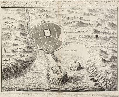
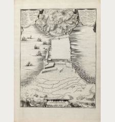
St. Sebastian. A strong fortified town of Guiapuscoa laying at the bottom of the Bay of...
William Henry Toms (*1700 - †1750)Antike Landkarte von San Sebastian. Gedruckt bei W. H. Toms im Jahre 1740 in London.
Artikel-Nr. 10990
Beschreibung
A very rare plan of San Sebastian in Spain by W.H. Toms
This copper engraved plan of San Sebastian was drawn by G. S. Baudwin and sold, engraved and published by W. H. Toms in 1741. Showing the fortified town with many ships in the harbour and a key from A to R with important buildings and places. At the bottom of the plate the participating persons are mentioned: 'Published August 13th 1740 and Sold by W. H. Toms Engraver in Union Court near Hatton Garden Holborn, and S. Harding on the Pavement in St. Martin's Lane. Price One Schilling'.
We only could locate one copy in COPAC at the British Museum of this rare separate published sheet.
Details
| Kartograph | William Henry Toms |
| Titel | St. Sebastian. A strong fortified town of Guiapuscoa laying at the bottom of the Bay of Biscay ... |
| Verlag, Jahr | W. H. Toms, London, 1740 |
| Bildgröße | 37.5 x 45.2 cm |
| Blattgröße | 41.2 x 46.3 cm |
Erhaltung
Bis auf den Plattenrand beschnitten, oben hinterlegter Papierstreifen von alter Bindung, kleiner Einriß in der Legende hinterlegt. Sehr guter Zustand.
Kartograph
W. H. Toms war als englischer Kupferstecher in London tätig. Zu seinen Werken zählen topographische und architektonische Ansichten.
Bilder zum Herunterladen
Falls Sie die Bilder dieser Karte in einer Auflösung von 1200 Pixeln herunterladen möchten, folgen Sie bitte unten stehendem Verweis.
Sie können die Bilder auf Ihrer privaten oder kommerziellen Internetseite frei veröffentlichen, sofern Sie einen Verweis (Link) auf diese Webseite setzen. Falls Sie Fotos in höherer Auflösung benötigen, kontaktieren Sie uns bitte.
William Henry Toms: St. Sebastian. A strong fortified town of Guiapuscoa laying at the bottom of the Bay of Biscay ....
Antike Landkarte von San Sebastian. Gedruckt bei W. H. Toms im Jahre 1740 in London.
Spanien - Portugal - Toms, William Henry - St. Sebastian. A strong fortified town of...

![Tabula nova Hispaniae [Tabula noua Hispaniae] Tabula nova Hispaniae [Tabula noua Hispaniae]](https://www.vintage-maps.com/3236-home_default/fries-spanien-portugal-1541.jpg)

![[Canary Islands] [Canary Islands]](https://www.vintage-maps.com/3021-home_default/bordone-spanien-portugal-kanaren-tenerife-gran-canaria.jpg)
