Product successfully added to your shopping cart
There are 0 items in your cart. There is 1 item in your cart.
Manuscript
![Blaeu, Manuscript, 1690: [Manuscript Chart of the South Atlantic Ocean] Tweede stuck wassende Graedkaert van de Kaap Verdische Eilanden tot de Kaap]( "Willem Janszoon Blaeu: [Manuscript Chart of the South Atlantic Ocean] Tweede stuck wassende Graedkaert van de Kaap Verdische Eilanden tot de Kaap")
[Manuscript Chart of the South Atlantic Ocean] Tweede stuck wassende Graedkaert van de Kaap...
Joan Blaeu II, Amsterdam, circa 1690
A Dutch East India Company (V.O.C.) Manuscript Chart by Joan Blaeu II on VellumFragment of a manuscript nautical chart of the Dutch East India Company (VOC) of the West African coast by Joan...
[Manuscript Chart of the South Atlantic Ocean] Tweede stuck wassende...
1690 - Willem Janszoon Blaeu
12620Manuscript sea chart on vellum of the Atlantic Ocean with the West African coast line. Drawn by Joan Blaeu II in Amsterdam.
14 800,00 €![Anonymous, Germany, Baden-Wuerttemberg, Danube, 1702: [Donau Strom von Sigmaringen bis Donauwörth]]( "Anonymous: [Donau Strom von Sigmaringen bis Donauwörth]")
[Donau Strom von Sigmaringen bis Donauwörth]
circa 1702
Important manuscript map of the Danube River in Upper Swabia on vellum.Very large, impressive and detailed manuscript map of the Danube river between Sigmaringen and Donauwörth. Drawn on...
[Donau Strom von Sigmaringen bis Donauwörth]
1702 - Anonymous
12078Manuscript map on vellum of Upper Swabia. Drawn around 1702.
8 500,00 €
Rotterdam
1760
Stunning 18th Century Manuscript Plan of Rotterdam.Manuscript map of Rotterdam, Delfshaven and surroundings by Barthélemy de La Rocque, a well-known Swiss draftsman and engraver. Shows the...
Rotterdam
1760 - Barthélemy de La Rocque
11737Manuscript plan of the Rotterdam by Barthélemy de La Rocque. Created 1760.
1 950,00 €
Plan Van Een Halve 6 Hoek na de Constructie Van de marchal de Vauban met een Wilkeurige Situatie...
1776
Carefully executed cartographic study, based on the methods of the French military corps Ingénieurs-Géographes , established by Vauban in 1696. With a charming title cartouche Plan Van Een Halve...
Plan Van Een Halve 6 Hoek na de Constructie Van de marchal de Vauban met...
1776 - Anonymous
12077Manuscript plan of a study on military cartography. Drawn in 1776.
490,00 €
Plan Van Een Halve 6 Hoek na de Constructie Van de marchal de Vauban met een Wilkeurige Situatie...
1777
Carefully executed cartographic study, based on the methods of the French military corps Ingénieurs-Géographes , established by Vauban in 1696. With a charming title cartouche Plan Van Een Halve...
Plan Van Een Halve 6 Hoek na de Constructie Van de marchal de Vauban met...
1777 - Anonymous
12076Manuscript plan of a study on military cartography. Drawn in 1777.
490,00 €![Anonymous, Netherlands, River Aa, 1780: [Aa-Berlicum-Erp]]( "Anonymous: [Aa-Berlicum-Erp]")
[Aa-Berlicum-Erp]
circa 1780
Charming and very detailed manuscript map of the river Aa from the late 18th century.Very detailed and elegantly executed manuscript map of the river Aa in Noord-Brabant between Berlicum and...
[Aa-Berlicum-Erp]
1780 - Anonymous
12060Manuscript map of the river Aa in Noord-Brabant between Berlicum and Erp. Created around 1780.
950,00 €
Neu York oder Neu Amsterdam
Knach, circa 1800
A charming manuscript drawing on vellum in brown ink of New York, signed 'Knach' with a German title 'Neu York oder Neu Amsterdam'. Around 1800. Provenance: A Swiss private collection.
Neu York oder Neu Amsterdam
1800 - Anonymous
10970Manuscript drawing on vellum of New York. Around 1800.
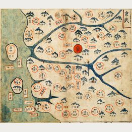
1 200,00 €![Anonymous, Korean Manuscript Atlas, Chonha-Chido, 1800: Ch'onha Chido [Atlas of all under Heaven]]( "Anonymous: Ch'onha Chido [Atlas of all under Heaven]")
Ch'onha Chido [Atlas of all under Heaven]
circa 1800
A Scarce Korean Manuscript Atlas.Rare Korean manuscript atlas with 12 maps, produced around 1800. With a world map (Chonha-Do) with China in the center, a map of China with Korea, a map of...
Ch'onha Chido [Atlas of all under Heaven]
1800 - Anonymous
12834Korean Manuscript Atlas, Ch'onha-Chido, around 1800
8 000,00 €![Anonymous, Korean Manuscript Atlas, Chonha-Chido, 1820: Ch'onha Chido [Atlas of all under Heaven]]( "Anonymous: Ch'onha Chido [Atlas of all under Heaven]")
Ch'onha Chido [Atlas of all under Heaven]
circa 1820
A Scarce Korean Manuscript Atlas.Album with 11 manuscript maps from a traditional Korean manuscript atlas, drawn in the early 19th century. With a China-centered world map (Chonha-Do), a map...
Ch'onha Chido [Atlas of all under Heaven]
1820 - Anonymous
12082Korean Manuscript Atlas, Ch'onha-Chido, early 19th Century
9 500,00 €
Palimpsest 1100 / 1300
1100 (1300)
A palimpsest with first hand writing partly erased from around 1100. On top of it, a Gothic script from around 1300. On parchment which was formerly used as part of a book cover.
Palimpsest 1100 / 1300
1100 - Anonymous
11616Manuscript on parchment written during the 12th and 14th century.
Sold
Plan du Rezdechaussee De l'Abbayé Royale de S. Andre En Gouffern Ordre de Citaux a Monseigneur le...
circa 1730
Plan manuscrit de l'Abbaye de Saint-André-en-Gouffern à La Hoguette, Calvados. Important manuscript map of the Abbey Saint-André-en-Gouffern in La Hoguette, Calvados.Large, impressive and...
Plan du Rezdechaussee De l'Abbayé Royale de S. Andre En Gouffern Ordre...
1730 - Anonymous
11525Manuscript plan of the Abbaye de Saint-Andre-de-Gouffern close to Falaise, Normandy. Created around 1730.
Sold![Anonymous, Germany, Waddenzee, Friesland, Delfzijl, Emden: [Manuscript Chart of the Wadden Sea at the Eems estuary]]( "Anonymous: [Manuscript Chart of the Wadden Sea at the Eems estuary]")
[Manuscript Chart of the Wadden Sea at the Eems estuary]
circa 1780
Two Stunning Manuscript Chart of the Wadden SeaDecorative manuscript chart of the shoals and sandbanks at the Eems estuary and surrounding the Wadden Sea islands Rottumeroog, Borkum and...
[Manuscript Chart of the Wadden Sea at the Eems estuary]
1780 - Anonymous
11453Old coloured map of Emden, Delfzijl, Friesland, Waddenzee. Printed circa 1780.
Sold![Anonymous, Korean Manuscript Atlas, Chonha-Chido, 1780: Ch'onha Chido [Atlas of all under Heaven]]( "Anonymous: Ch'onha Chido [Atlas of all under Heaven]")
Ch'onha Chido [Atlas of all under Heaven]
circa 1780
A Scarce Korean Manuscript Atlas.Album with 12 manuscript maps from a traditional Korean manuscript atlas, drawn in the late 18th century. With a China-centered world map (Chonha-Do), a map...
Ch'onha Chido [Atlas of all under Heaven]
1780 - Anonymous
12081Korean Manuscript Atlas, Ch'onha-Chido, late 18th Century
Sold![Anonymous, Korean Manuscript, Chonha-Do, 1820: [Korean Manuscript Map of the World]]( "Anonymous: [Korean Manuscript Map of the World]")
[Korean Manuscript Map of the World]
circa 1820
Stunning Korean Manuscript World Map from a Chonha-Chido .An early 1800's Korean manuscript world map based on a map produced during the Chinese Ming Empire (1368-1644). The map comes from...
[Korean Manuscript Map of the World]
1820 - Anonymous
11503Korean Manuscript World Map (Chonha-Do) from the early 1800s
Sold![Anonymous, Japan - Korea, Korean Manuscript, 1820: [Korean Manuscript Map of China and Korea]]( "Anonymous: [Korean Manuscript Map of China and Korea]")
[Korean Manuscript Map of China and Korea]
circa 1820
Stunning Korean Manuscript Map of China and Korea from a Chonha-Chido .An early 1800's Korean manuscript map of China with Korea ( Choson Kukto ). The map comes from a traditional Korean...
[Korean Manuscript Map of China and Korea]
1820 - Anonymous
11504Traditional Korean Manuscript Map of China and Korea from the early 1800s
Sold![Anonymous, Japan - Korea, Kyonggi-do, Gyeonggi-do, Seoul: [Korean Manuscript Map of Kyonggi-do with Seoul]]( "Anonymous: [Korean Manuscript Map of Kyonggi-do with Seoul]")
[Korean Manuscript Map of Kyonggi-do with Seoul]
circa 1820
Stunning Korean Manuscript Map of Kyonggi with Seoul from a Chonha-Chido .An early 1800's Korean manuscript map of Kyonggi-do (Gyeonggi-do) with Seoul. The map comes from a traditional...
[Korean Manuscript Map of Kyonggi-do with Seoul]
1820 - Anonymous
11505Traditional Korean Manuscript Map of Kyonggi-do with Seoul from the early 1800s
Sold![Anonymous, Netherlands, Haarlem, 1841: [Manuscript Plan Leidsevaart]]( "Anonymous: [Manuscript Plan Leidsevaart]")
[Manuscript Plan Leidsevaart]
1841
Manuscript plan of the Leidsevaart in Haarlem. Shows part of the Leidsevaartbuurt in Haarlem (partly still Veen Polder ) with the Pijlslaan and Het Schouwtje . With numbered parcellation, the...
[Manuscript Plan Leidsevaart]
1841 - Anonymous
12074Manuscript map of the Leidsevaart in Haarlem. Drawn in 1841.
Sold![Anonymous, Netherlands, Haarlem, 1846: [Manuscript Plan Leidsevaart]]( "Anonymous: [Manuscript Plan Leidsevaart]")
[Manuscript Plan Leidsevaart]
1846
Manuscript plan of the Leidsevaart in Haarlem. Shows the area along the Leidsevaart ("Lijdsche Vaart"), at the junction between Heemstede, Bennebroek (with "Huis te Bijweg" on the "Heeren Weg") and...
[Manuscript Plan Leidsevaart]
1846 - Anonymous
12075Manuscript map of the Leidsevaart in Haarlem. Drawn in 1846.
Sold
Gemeente Haarlem Sectie E Schaal van 1 à 1250
1884
Manuscript plan of the Oude Amsterdamse Buurt in Haarlem. With letterpress (and partly manuscript) in three corners Uittreksel uit het Kadastrale Plan , Afgegeven door mij Bewaarder van de...
Gemeente Haarlem Sectie E Schaal van 1 à 1250
1884 - Anonymous
12061Manuscript map of the Oude Amsterdamse Buurt in Haarlem. Drawn in 1884.
Sold
![Blaeu, Manuscript, 1690: [Manuscript Chart of the South Atlantic Ocean] Tweede stuck wassende Graedkaert van de Kaap Verdische Eilanden tot de Kaap](https://www.vintage-maps.com/3745-home_default/blaeu-manuscript-1690.jpg "Willem Janszoon Blaeu: [Manuscript Chart of the South Atlantic Ocean] Tweede stuck wassende Graedkaert van de Kaap Verdische Eilanden tot de Kaap")
![Anonymous, Germany, Baden-Wuerttemberg, Danube, 1702: [Donau Strom von Sigmaringen bis Donauwörth]](https://www.vintage-maps.com/2606-home_default/anonymous-germany-baden-wuerttemberg-danube-1702.jpg "Anonymous: [Donau Strom von Sigmaringen bis Donauwörth]")


![Anonymous, Netherlands, River Aa, 1780: [Aa-Berlicum-Erp]](https://www.vintage-maps.com/2588-home_default/anonymous-netherlands-river-aa-1780.jpg "Anonymous: [Aa-Berlicum-Erp]")

![Anonymous, Korean Manuscript Atlas, Chonha-Chido, 1800: Ch'onha Chido [Atlas of all under Heaven]](https://www.vintage-maps.com/4291-home_default/anonymous-korean-manuscript-atlas-chonha-chido-1800.jpg "Anonymous: Ch'onha Chido [Atlas of all under Heaven]")
![Anonymous, Korean Manuscript Atlas, Chonha-Chido, 1820: Ch'onha Chido [Atlas of all under Heaven]](https://www.vintage-maps.com/3336-home_default/anonymous-korean-manuscript-atlas-chonha-chido-1820.jpg "Anonymous: Ch'onha Chido [Atlas of all under Heaven]")


![Anonymous, Germany, Waddenzee, Friesland, Delfzijl, Emden: [Manuscript Chart of the Wadden Sea at the Eems estuary]](https://www.vintage-maps.com/1707-home_default/anonymous-germany-waddenzee-friesland-delfzijl-emden.jpg "Anonymous: [Manuscript Chart of the Wadden Sea at the Eems estuary]")
![Anonymous, Korean Manuscript Atlas, Chonha-Chido, 1780: Ch'onha Chido [Atlas of all under Heaven]](https://www.vintage-maps.com/3325-home_default/anonymous-korean-manuscript-atlas-chonha-chido-1780.jpg "Anonymous: Ch'onha Chido [Atlas of all under Heaven]")
![Anonymous, Korean Manuscript, Chonha-Do, 1820: [Korean Manuscript Map of the World]](https://www.vintage-maps.com/1811-home_default/anonymous-korean-manuscript-chonha-do-1820.jpg "Anonymous: [Korean Manuscript Map of the World]")
![Anonymous, Japan - Korea, Korean Manuscript, 1820: [Korean Manuscript Map of China and Korea]](https://www.vintage-maps.com/1812-home_default/anonymous-japan-korea-korean-manuscript-1820.jpg "Anonymous: [Korean Manuscript Map of China and Korea]")
![Anonymous, Japan - Korea, Kyonggi-do, Gyeonggi-do, Seoul: [Korean Manuscript Map of Kyonggi-do with Seoul]](https://www.vintage-maps.com/1813-home_default/anonymous-japan-korea-kyonggi-do-gyeonggi-do-seoul.jpg "Anonymous: [Korean Manuscript Map of Kyonggi-do with Seoul]")
![Anonymous, Netherlands, Haarlem, 1841: [Manuscript Plan Leidsevaart]](https://www.vintage-maps.com/2602-home_default/anonymous-netherlands-haarlem-1841.jpg "Anonymous: [Manuscript Plan Leidsevaart]")
![Anonymous, Netherlands, Haarlem, 1846: [Manuscript Plan Leidsevaart]](https://www.vintage-maps.com/2603-home_default/anonymous-netherlands-haarlem-1846.jpg "Anonymous: [Manuscript Plan Leidsevaart]")
