Product successfully added to your shopping cart
There are 0 items in your cart. There is 1 item in your cart.
Total products
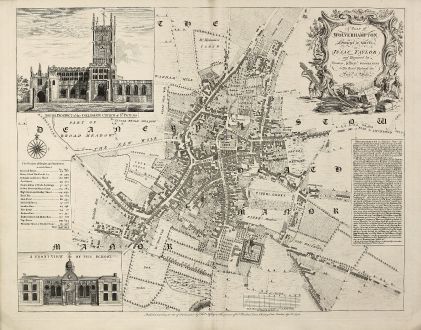
A Plan of Wolverhampton Surveyed in MDCCL By Isaac Taylor and Engraved by Thomas...
Thomas Jefferys (*1695 - †1771)Antique map of Wolverhampton, Staffordshire. Printed in London by Thomas Jefferys in 1751.
Reference 10978
Description
Important and rare plan of Wolverhampton by T. Jefferys
A large and detailed copper engraved plan of Wolverhampton engraved and published by Thomas Jefferys in 1751 after a survey of Isaac Taylor in 1750. Oriented with north to the top of the page, the plan is dedicated by Jefferys to 'His Royal Highness the Prince of Wales'. A decorative title cartouche appears in the upper right corner, two large vignette illustrations of 'South Prospect of the Collegiate Church of St. Peters' and 'A Front View of the School' in the left corners, a description of the town and a list of the streets with number of houses and inhabitants. At the bottom of the plate the address of Jefferys: 'Publish'd according to Act of Parliament by Thos. Jefferys at the Corner at the Corner of St. Martin's Lane, Charing Cross London, Aprl. 8. 1751.'
This is first state of the map, printed and published just months after the survey as a separate map. We only could locate a handful of copies of this map in Libraries world wide.
Details
| Cartographer | Thomas Jefferys |
| Title | A Plan of Wolverhampton Surveyed in MDCCL By Isaac Taylor and Engraved by Thomas Jefferys Geographer to His Royal Highness the Prince of Wales. |
| Publisher, Year | Thomas Jefferys, London, 1751 |
| Plate Size | 49.0 x 61.2 cm (19.3 x 24.1 inches) |
| Sheet Size | 53.0 x 67.9 cm (20.9 x 26.7 inches) |
Condition
Perfect condition. It is quite unusual to find a separate published map in such preservation.
Cartographer
Thomas Jefferys was an english cartographer and publisher. He produced one of the finest maps of the time of the West Indies and North America. Jefferys also published english country maps.
Images to Download
If you like to download the image of this map with a resolution of 1200 pixels, please follow the link below.
You can use this image for publication on your personal or commercial websites for free if you set a link to this website. If you need photographs with a higher resolution, please contact us.
Thomas Jefferys: A Plan of Wolverhampton Surveyed in MDCCL By Isaac Taylor and Engraved by Thomas Jefferys Geographer to His Royal Highness....
Antique map of Wolverhampton, Staffordshire. Printed in London by Thomas Jefferys in 1751.
British Isles - Jefferys, Thomas - A Plan of Wolverhampton Surveyed in MDCCL...


![[British Isles and England & Wales] [British Isles and England & Wales]](https://www.vintage-maps.com/2941-home_default/bordone-british-isles-england-and-wales-1528-1565.jpg)

![[The Firth of Murry] - To the Rt Hon.ble, my Lord Viscount Torbat, Lord Register of the Kingdom of Scotland [The Firth of Murry] - To the Rt Hon.ble, my Lord Viscount Torbat, Lord Register of the Kingdom of Scotland](https://www.vintage-maps.com/2244-home_default/collins-scotland-north-sea-moray-firth-inverness.jpg)
