Menu
- Antique Maps
- Atlases
- Globes
- Cartographers
- Aa, Pieter van der
- Adams, John
- Adrichem, Christian
- Albizzi, Antonio
- Allard, Carel
- Allard, Hugo
- Altmannshausen, Johann Ernst von
- Angelocrator, Daniel
- Anguissola, Leander
- Anonymous
- Bachmann, John
- Bailleul le Jeune, Nicolas
- Barbault, Jean
- Bayer, Johann
- Beaurain, Jean de
- Beek, Anna
- Belleforest, Francois de
- Bellin, Jacques Nicolas
- Bellus, Nicolaus
- Bertius, Petrus
- Bibliographisches Institut
- Bickham, George
- Blaeu, Joan
- Blaeu, Willem Janszoon
- Bodenehr, Gabriel
- Bodmer, Karl
- Boethius, Christoph
- Bonifacio, Natal
- Bonne, Rigobert
- Bordone, Benedetto
- Borgia, Stefano
- Botero, Giovanni
- Bowen, Emanuel
- Bowles and Carver
- Bowles, Thomas
- Braun & Hogenberg
- Breydenbach, Bernhard von
- Brion de la Tour, Louis
- British Admiralty
- Bry, Theodor de
- Bucelin, Gabriel
- Buffon, G.-L. Leclerc de
- Bünting, Heinrich
- Bussemacher, Johann
- Call, Pieter van
- Camocio, Giovanni Francesco
- Caoursin, Guillaume
- Cary, John
- Cellarius, Andreas
- Celtis, Konrad
- Chaffat, Antoine du
- Chapman and Hall
- Clouet, Jean Baptiste Louis
- Clüver, Phillip
- Collins, Greenville
- Coronelli, Vincenzo Maria
- Covens and Mortier
- Curtis, William
- d'Anville, Jean Baptiste
- Danckerts, Justus
- Danckerts, Theodorus
- de l'Isle, Guillaume
- De Pierre
- Delamarche, Charles Francois
- Deroy, Isidore Laurent
- Doncker, Hendrick
- Doppelmayr, Johann Gabriel
- Downing, Alexander
- Drummond, Alexander
- Dudley, Robert
- Duflos, Claude
- Edwards, Sydenham Teak
- Ellis, Joseph
- Elwe, Jan Barend
- Euler, Leonhard
- Faden, William
- Fer, Nicolas de
- Flinders, Matthew
- Fouquet, Pieter
- Fourdrinier, Pierre
- Fricx, Eugene Henri
- Fries, Laurent
- Garden, Francis
- Geographisches Institut Weimar
- Goos, Abraham
- Goos, Pieter
- Greenwood, Christopher
- Haffner, Johann Christoph
- Haupt, Gottfried Jacob
- Holle, Lienhart
- Homann Erben
- Homann, Johann Baptist
- Homann, Johann Christoph
- Hondius, Jodocus
- Hondt, Pieter de
- Hooker, William
- Husson, Pierre
- Jaillot, Alexis Hubert
- Janssonius, Johannes
- Jefferys, Thomas
- Jode, Gerard de
- Johnston, Alexander Keith
- Jombert, Charles Antoine
- Jonston, John
- Julien, Roch Joseph
- Keere, Pieter van den
- Keulen, Johannes van
- Kilian, Georg Christoph
- Kip, William
- Kitchin, Thomas
- Langlois, Hyacinthe
- Laurie & Whittle
- le Clerc, Nicolas Gabriel
- le Rouge, George Louis
- Lempriere, Clement
- Lespinasse, Nicolas Louis de
- Lesson, René Primevère
- Linschoten, Jan Huygen van
- Little, William
- Loots, Johannes
- Lotter, Tobias Conrad
- Magini, Giovanni Antonio
- Magnus, Olaus
- Mallet, Alain Manesson
- Mann, Fred & Helen
- Mannevillette, Jean Baptiste
- Mariette, Jean
- Mayer, Tobias
- Medina, Pedro de
- Megenberg, Konrad von
- Meissner, Daniel
- Mejer, Johannes
- Mercator, Gerard
- Mercator, Michael
- Mercator, Rumold
- Merian, Maria Sibylla
- Merian, Matthäus
- Middiman, Samuel
- Montanus, Arnoldus
- Morden, Robert
- Mortier, David
- Mortier, Pieter
- Mosley, Charles
- Mount & Page
- Münster, Sebastian
- Mynde, James
- Nolin, Jean Baptiste
- Noort, Olivier van
- Norden, Frederick Louis
- Ortelius, Abraham
- Ottens, Reiner
- Owen & Bowen
- Peck, Francis
- Pigeot, Francois
- Pitt, Moses
- Pluche, Noel Antoine
- Poggibonsi, Niccolo da
- Porcacchi, Tomaso
- Porro, Girolamo
- Ptolemaeus, Claudius
- Pufendorf, Samuel Baron von
- Quad, Matthias
- Raigniauld, Henry
- Ramusio, Giovanni Battista
- Rastrick, Gulielmus
- Regnault, Nicolas François
- Reilly, Franz Johann Joseph von
- Renard, Louis
- Riemer, Jacob de
- Robert de Vaugondy, Gilles
- Robert, Nicolas
- Rocque, Barthélemy de La
- Rocque, John
- Rossetti, Domenico
- Rossi, Giovanni Giacomo
- Roy, Bernard de
- Ruscelli, Girolamo
- Russell, John
- Sanson, Nicolas
- Saur, Abraham
- Schedel, Hartmann
- Schenk, Pieter
- Scheuchzer, Johann Jakob
- Schindelmayer, Carl Robert
- Schley, Jakob van der
- Schmidt, Johann Friedrich Julius
- Schotanus van Sterringa, Bernhard
- Schreiber, Johann Georg
- Schwabe, Johann Joachim
- Seale, Richard William
- Seller, John
- Seutter, George Matthäus
- Shaw, Thomas
- Smallegange, Mattheus
- Smith, Charles
- Speed, John
- Stampioen, Jan Janszoon
- Stieler, Adolf
- Stockdale, John
- Stöcklein, Joseph
- Stoopendaal, Daniel
- Sylvanus, Bernardus
- Tallis, John
- Tardieu, Pierre François
- Thornton, John
- Tirinus, Jacobus
- Tirion, Isaak
- Toms, William Henry
- Ughi, Lodovico
- Valegio, Francesco
- Valk & Schenk
- Valk, Gerard
- Verneau, Charles
- Vidal y Pinilla, Felipe
- Visscher, Nicolas
- Waghenaer, Lucas Janszoon
- Waldseemüller, Martin
- Weigel, Christoph
- Weis, Franz Joseph
- Wells, Edward
- Whitbread, Josiah
- Wit, Frederick de
- Wytfliet, Cornelius
- Zenoi, Domenico
- Zoutman, Jan Dirksz
- Graphics
- New Additions
Cart
0 Product: Products: (empty)
No products
Product successfully added to your shopping cart
There are 0 items in your cart. There is 1 item in your cart.
Total products
Continue shopping Proceed to checkout
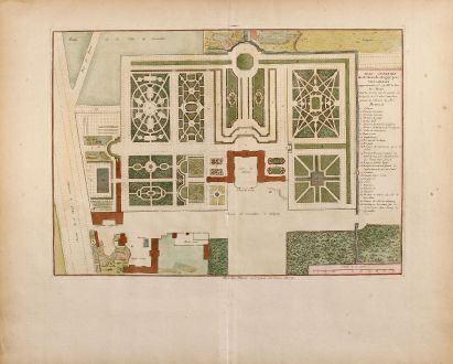
Plan general du Chateau de Clagny pres Versailles
Jean Mariette (*1660 - †1742)Description
Coloured engraving of the park and garden of the castle in Versailles / France.
Details
| Cartographer | Jean Mariette |
| Title | Plan general du Chateau de Clagny pres Versailles |
| Publisher, Year | circa 1730 |
| Plate Size | 29.0 x 41.3 cm (11.4 x 16.3 inches) |
Condition
Excellent conditions in beautiful colours.
Cartographer
Jean Mariette, born 1660 in Paris, was a french engraver and publisher with close connection to the Langlois publishing family of the famous rue St. Jacques in Paris. He died in 1742.
Images to Download
If you like to download the image of this map with a resolution of 1200 pixels, please follow the link below.
You can use this image for publication on your personal or commercial websites for free if you set a link to this website. If you need photographs with a higher resolution, please contact us.
Jean Mariette: Plan general du Chateau de Clagny pres Versailles.
Old coloured city plan of Versailles. Printed circa 1730.
France - Mariette, Jean - Plan general du Chateau de Clagny pres...

